Sign In
Home
Popular
News
Popular now
New music
Cute animals
Trending today
Hot trailers
Popular music
Comedy clips
New tech
Popular sports
Learn new
Buy real YouTube subscribers. Best price and warranty.
Animals
Babies
Beautiful
Cats
Creative
Cute
Dogs
Educational
Funny
Heartwarming
Holidays
Incredible
Inspirational
Interesting
Love
Music
Nature
Oops
Performance
Pranks
Science
Sports
Technology
Unexpected
Best Cat Humor
Best Puppy Show
Music Talent Competition
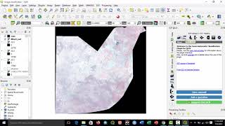
Geoinformation production
0
Please subscribe to my YouTube channel
posted by
meirbhn9
introduction to spatial analysis using python by Geoinformation production 59 views 1 year ago 33 minutes
LAndsat image download by Geoinformation production 22 views 1 year ago 32 minutes
Heatmap and time mapping by Geoinformation production 21 views 1 year ago 31 minutes
Soil erodibility factor (k factor) in ArcGIS by Geoinformation production 3,647 views 2 years ago 28 minutes
Rainfall erosivity factor (R factor) in ArcGIS by Geoinformation production 1,167 views 2 years ago 28 minutes
3D flood mapping in Arcscene(ArcGis) by Geoinformation production 44 views 2 years ago 24 minutes
contour and 3d model in surfer by Geoinformation production 109 views 2 years ago 24 minutes
LST in ARCmap by Geoinformation production 31 views 2 years ago 58 minutes
Kriging in Arcmap by Geoinformation production 9 views 2 years ago 8 minutes, 56 seconds
NDWI, image classification and NDVI by Geoinformation production 183 views 2 years ago 57 minutes
Hotspot analysis in Arcgis by Geoinformation production 202 views 2 years ago 15 minutes
Geocoding and Map publishing in QGIS by Geoinformation production 47 views 2 years ago 36 minutes
Landcover map in IDRISI TERRSET by Geoinformation production 4,005 views 2 years ago 33 minutes
Introduction to GIS and QGIS by Geoinformation production 10 views 3 years ago 23 minutes
Stream extraction, watershed basin,contour and 3d modeling in Qgis by Geoinformation production 76 views 3 years ago 52 minutes
NDVI and NDWI in QGIS by Geoinformation production 573 views 3 years ago 27 minutes
hotspot analysis in ArcGis by Geoinformation production 68 views 3 years ago 15 minutes
Land use mapping/image classification in Qgis 3.12 by Geoinformation production 56 views 3 years ago 38 minutes
Accessing satellite imagery in QGIS by Geoinformation production 111 views 3 years ago 8 minutes, 37 seconds
Recommended
Mobile Phone Service: Wash & Destroy!
01:39
Best Way To Find Your Car Anywhere You Need!
00:38
5 Shirt Hacks Every Man Should Know
01:25
Best of Dude Perfect - Adrenalin Bomb Of The Year 2016
07:10