Sign In
Home
Popular
News
Popular now
New music
Cute animals
Trending today
Hot trailers
Popular music
Comedy clips
New tech
Popular sports
Learn new
Secret sauce that brings YouTube followers, views, likes
Animals
Babies
Beautiful
Cats
Creative
Cute
Dogs
Educational
Funny
Heartwarming
Holidays
Incredible
Inspirational
Interesting
Love
Music
Nature
Oops
Performance
Pranks
Science
Sports
Technology
Unexpected
Funny Kittens
Watch Cute Dogs
Promote Cover Music
Geospatial Information Hub
0
Welcome to Geospatial Hub
Here you can get all the videos related to GIS and Remote Sensing
posted by
boderax3
How to change Coordinate System of shapefile in ArcGis and check the difference in Area and Length by Geospatial Information Hub 279 views 11 months ago 5 minutes, 39 seconds
Create Digital Elevation Model , Contour and Slope in Arc GIS . FOR BEGINNERS by Geospatial Information Hub 1,547 views 2 years ago 6 minutes, 38 seconds
Supervised Image Classification in ERDAS Imagine by Geospatial Information Hub 88 views 2 years ago 10 minutes, 7 seconds
How to prepare Map Layout in ArcGIS - Landuse Map by Geospatial Information Hub 300 views 2 years ago 22 minutes
Flood Simulation Model in Arc Scene/ 3D Flood Animation by Geospatial Information Hub 517 views 3 years ago 8 minutes, 12 seconds
How to change projection from Everest1830 to WGS1984 |Datum Transformation in Arc GIS by Geospatial Information Hub 5,844 views 3 years ago 9 minutes, 37 seconds
Learn how to install ArcGIS 9.3 cack ! by Geospatial Information Hub 1,354 views 3 years ago 9 minutes, 15 seconds
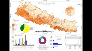
Thematic Mapping on Covid-19 Tutorial l। Data Downloading, Data Entry & Layouting ।। Part-2 by Geospatial Information Hub 475 views 3 years ago 41 minutes
Thematic Mapping on Covid-19 Tutorial l। Data Downloading, Data Entry & Layouting ।। Part-1 by Geospatial Information Hub 757 views 3 years ago 59 minutes
AutoCAD Workshop Part-5 by Geospatial Information Hub 322 views 3 years ago 1 hour, 28 minutes
AutoCAD Workshop Part-4 by Geospatial Information Hub 39 views 3 years ago 26 minutes
AutoCAD Workshop Part-3 by Geospatial Information Hub 85 views 3 years ago 56 minutes
AutoCAD Workshop Part-2 by Geospatial Information Hub 135 views 3 years ago 1 hour, 40 minutes
Engineering Drawing ।। projection of lines by Geospatial Information Hub 173 views 4 years ago 14 minutes, 54 seconds
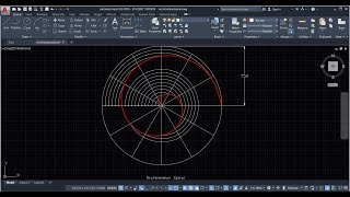
Engineering Drawing ।। Archimedean Spiral by Geospatial Information Hub 8,884 views 4 years ago 11 minutes, 10 seconds
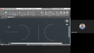
Engineering Drawing ।। Ellipse by Geospatial Information Hub 106 views 4 years ago 6 minutes, 46 seconds
How to Download High Resolution Aerial Imagery of resolution of 0.3m ।। Geospatial Information Hub by Geospatial Information Hub 484 views 4 years ago 4 minutes, 6 seconds
Conic Sections ।। Toy Rocket by Geospatial Information Hub 257 views 4 years ago 11 minutes, 25 seconds
How to display your Grid in AutoCAD? by Geospatial Information Hub 1,034 views 4 years ago 49 seconds
AutoCAD workshop part-1 ।। Day - 1 by Geospatial Information Hub 859 views 4 years ago 1 hour, 4 minutes
QGIS 3.14 Tutorial ।। Create contour and DEM ।। Google Earth ।। Geospatial Information Hub by Geospatial Information Hub 73,777 views 4 years ago 10 minutes, 51 seconds
How to extract Study Area from Google Earth and export in ArcGIS ! by Geospatial Information Hub 6,754 views 4 years ago 4 minutes, 21 seconds
Learn How to create Digital Elevation Model (DEM) using Google Earth in ArcGIS by Geospatial Information Hub 317 views 4 years ago 6 minutes, 15 seconds
Recommended
Monday Is Meant For Everyone, Even Dogs!
00:56
Hands Up, Forks Down: Hunger Police Is Here!
04:34
Gymnastics Coach Shows Highest Level Of Skills!
00:13
Wedding Speeches Are Such Wedding Speeches!
03:45
100 Years of Oriental Beauty Standards
00:01
Best Way To Find Your Car Anywhere You Need!
00:38