Unlock the power of Geographic Information Systems (GIS) and Remote Sensing with our comprehensive tutorials and insights. Whether you're a GIS beginner or an experienced analyst, this channel offers valuable resources to enhance your skills and knowledge.
What You'll Learn:
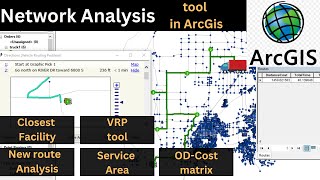
GIS Tutorials: Master ArcGIS, QGIS, and other GIS software with our stepbystep guides. Remote Sensing: Discover techniques for processing and analyzing satellite imagery and aerial data. Spatial Data Analysis: Learn how to manage, analyze, and visualize geospatial data effectively. Programming for GIS: Automate workflows and enhance your projects using Python and R. RealWorld Projects: Explore indepth case studies and project walkthroughs. Why Subscribe? GIS tutorials Learn ArcGIS QGIS training Remote sensing techniques Spatial data analysis Python for GIS R programming for GIS Geospatial data visualization