Sign In
Home
Popular
News
Popular now
New music
Cute animals
Trending today
Hot trailers
Popular music
Comedy clips
New tech
Popular sports
Learn new
Secret weapon how to promote your YouTube channel
Animals
Babies
Beautiful
Cats
Creative
Cute
Dogs
Educational
Funny
Heartwarming
Holidays
Incredible
Inspirational
Interesting
Love
Music
Nature
Oops
Performance
Pranks
Science
Sports
Technology
Unexpected
Cat Videos
Best Dog Videos
Best Covers
LatLongCoder
0
All about Geospatial Technologies and Data Science
posted by
Mamcarzpt
Use Python in Raster Calculator to generate thousands of rasters at once | ArcGIS Pro | ArcMap by LatLongCoder 340 views 1 year ago 2 minutes, 6 seconds
Python Automation in ArcGIS Pro/ArcMap | ArcPy Raster Calculator | 1,000 maps using simple codes by LatLongCoder 903 views 1 year ago 26 minutes
Time Series Raster Animation in Python | Rasterio | Imageio by LatLongCoder 550 views 1 year ago 25 minutes
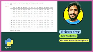
Web Scraping with Python | Data Cleaning | Data Visualization | Very Easy ! by LatLongCoder 223 views 1 year ago 32 minutes
Geospatial Deep Learning in ArcGIS Pro | ChatGPT for GIS | Faster R-CNN by LatLongCoder 1,828 views 1 year ago 29 minutes
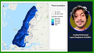
Creating Professional Map Layout in ArcGIS Pro | Template for any Study Area|@LatLongCoder by LatLongCoder 7,444 views 1 year ago 33 minutes
Plot Multiple Line Graphs with Two y-axis in MATLAB | Data Visualization | Stem Plot|for Beginner by LatLongCoder 674 views 1 year ago 21 minutes
Linear Regression Line in R | Plotting Scatter Plot in R studio | ggplot2 package | Statistics by LatLongCoder 617 views 1 year ago 28 minutes
Mann-Kendall Trend & Sen's Slope Test in R Studio || R Programming || Statistics by LatLongCoder 10,765 views 1 year ago 14 minutes, 24 seconds
Plot Group Bar Graphs in MATLAB | Multiple Varibles | Base Line Shift | Basic to Advanced Level by LatLongCoder 202 views 1 year ago 29 minutes
MATLAB Tutorial | Getting Started | Importing Excel Data & Making Professional Bar Chart by LatLongCoder 611 views 1 year ago 23 minutes
Calculating Spatial Statistics ( mean, medain, std ) from NetCDF Data | Xarray Library | Python by LatLongCoder 1,771 views 2 years ago 22 minutes
Reading NetCDF (.nc) data with Xarray in Python | For beginners | Python | Xarray| Jupyter notebook by LatLongCoder 6,263 views 2 years ago 28 minutes
How to make Raster (TIF) from NetCDF file in ArcMap || Working with NC file format in GIS by LatLongCoder 2,564 views 2 years ago 12 minutes, 8 seconds
Download any images with Google Earth Engine || SRTM DEM || Clip in GEE by LatLongCoder 819 views 2 years ago 14 minutes, 12 seconds
Adding Customised Legend in Google Earth Images || Full Tutorial || Codes Explained || JS || CSS by LatLongCoder 706 views 2 years ago 42 minutes
Exporting Images from Google Earth Engine |To Google Drive |To Earth Engine Assets |JS Coding on GEE by LatLongCoder 564 views 2 years ago 24 minutes
Supervised Landsat8 Classification in Google Earth Engine | Full Tutorial with Code Explanation | JS by LatLongCoder 404 views 2 years ago 35 minutes
Connecting PostGIS Database with QGIS | Working with PostgreSQL | PgAdmin4 by LatLongCoder 1,223 views 2 years ago 17 minutes
Plot Multiple Lines in Microsoft Excel | Landsat Image Stats in Graphs | Excel Basics | Ramadan 22 by LatLongCoder 179 views 2 years ago 10 minutes, 50 seconds
Adding Geometry |Adding Point, Line & Polygon Feature | pgAdmin | Postgres| PostGIS| SQL Debugging by LatLongCoder 5,122 views 2 years ago 44 minutes
PostgreSQL | PgAdmin4 |Importing CSV/Text file | SQL codes| Database| Schemas|Tables| For Beginner by LatLongCoder 6,912 views 2 years ago 33 minutes
Lesson 3 | How to extract Study Area with desired Date| JavaScritp Coding | Google Earth Engine by LatLongCoder 218 views 2 years ago 25 minutes
JavaScritp API | Getting started with Google Earth Engine | Image loading with JS Coding | Lesson 2 by LatLongCoder 306 views 2 years ago 24 minutes
Google Earth Engine | JavaScript | Declaring Variable | Image Loading | Lesson 2 | For Beginners ! by LatLongCoder 151 views 2 years ago 25 minutes
Google Earth Engine | GEE | Introduction to the Interface & Functionality | Lesson 1| For beginners by LatLongCoder 559 views 2 years ago 15 minutes
GIS Python | Dealing with Feature Class | Arcpy | ListFeatureClasses | Describe| basename |shapeType by LatLongCoder 501 views 2 years ago 12 minutes, 47 seconds
Python Programming | GIS | We are ready to leverage ur coding skills | Plz subscrive to this Channel by LatLongCoder 216 views 2 years ago 4 minutes, 12 seconds
Learn Python: ArcPy Environment Setting | Dissolve Management in Python Window. For Beginners by LatLongCoder 440 views 2 years ago 30 minutes
Python Script | Duplicate-Check in Attribute Table |ArcGIS | Jupyter Notebook | First Video in USA by LatLongCoder 1,686 views 2 years ago 13 minutes, 52 seconds
Recommended
Face Masks Have Never Been So Natural Before!
06:21
One Magic Wish & Zero Genie In A Bottle
14:32
Beaty Standards Around The World
02:06
Speaker, Paint, Go!
12:48
Best Way To Kill Your Time While Sitting In The Office
05:04
No Kisses For Waking Up Old Princesses!
01:53
This Guy Would Easily Overshadow Pippi Longstocking!
06:07
Say Goodbye To Heavy Traffic Forever!
03:55
Revenge - Sweet Dessert With No Harm To Your Figure!
00:34
If Taylor Swift Had A Pug, He Would Look Like This!
02:03