Sign In
Home
Popular
News
Popular now
New music
Cute animals
Trending today
Hot trailers
Popular music
Comedy clips
New tech
Popular sports
Learn new
Grow your YouTube views, likes and subscribers for free
Animals
Babies
Beautiful
Cats
Creative
Cute
Dogs
Educational
Funny
Heartwarming
Holidays
Incredible
Inspirational
Interesting
Love
Music
Nature
Oops
Performance
Pranks
Science
Sports
Technology
Unexpected
Best Cat Humor
Best Puppy Show
Cover Song Charts
OpenTopography
0
OpenTopography is a National Science Foundationfunded data facility focused on highresolution topographic data, and related tools and resources. More information and data access: https://opentopography.org/
posted by
seramies71
How to Cite Data from OpenTopography by OpenTopography 220 views 1 month ago 1 minute
24 Package & Export All Project Files in ArcGIS Pro by OpenTopography 280 views 3 months ago 6 minutes, 4 seconds
23 Export Oblique View of Map from Local Scene in ArcGIS Pro by OpenTopography 267 views 3 months ago 2 minutes, 41 seconds
22 Exporting Map PDF using Layout View in ArcGIS Pro by OpenTopography 315 views 4 months ago 7 minutes, 22 seconds
21 Final Geologic Map in 3D using ArcGIS Pro by OpenTopography 519 views 4 months ago 1 minute, 10 seconds
19 Adding and Editing Contour Line Labels in ArcGIS Pro by OpenTopography 231 views 4 months ago 2 minutes, 25 seconds
20 Exporting Layer Files (.lyrx) & Layer Packages (.lpkx) in ArcGIS Pro by OpenTopography 516 views 4 months ago 5 minutes, 19 seconds
18 Adding Map Unit Polygon Labels & Adjusting Label Properties in ArcGIS Pro by OpenTopography 285 views 4 months ago 6 minutes, 36 seconds
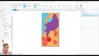
17 Building Map Unit Polygons Using Feature To Polygon Tool in ArcGIS Pro by OpenTopography 304 views 4 months ago 8 minutes, 53 seconds
16 Running Topology Wizard Tool (Error Checker) to Fix Geologic Linework in ArcGIS Pro by OpenTopography 302 views 4 months ago 9 minutes, 21 seconds
15 Drawing Geologic Contacts in ArcGIS Pro by OpenTopography 301 views 4 months ago 7 minutes, 46 seconds
14 Choosing a Basemap, Drawing Linear Features, & Flip Line Tool in ArcGIS Pro by OpenTopography 210 views 4 months ago 7 minutes, 44 seconds
13 Deciding Publication & Digitization Scale & Drawing Map Border in ArcGIS Pro by OpenTopography 261 views 4 months ago 5 minutes, 48 seconds
12 Building Geologic Unit Polygon Symbology in ArcGIS Pro by OpenTopography 271 views 4 months ago 6 minutes, 29 seconds
11 Building Feature Class Symbology for Contacts & Linear Features in ArcGIS Pro by OpenTopography 281 views 4 months ago 7 minutes, 51 seconds
9 Creating Mapping Feature Datasets and Feature Classes in ArcGIS Pro by OpenTopography 431 views 4 months ago 12 minutes, 13 seconds
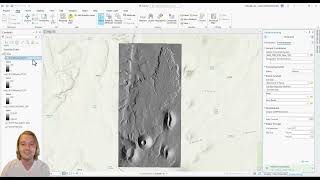
8 Visualizing Data in 3D Using Local Scene in ArcGIS Pro by OpenTopography 917 views 4 months ago 8 minutes, 6 seconds
7 Measure Tool, 2D Topographic Profiles, and Contour Lines in ArcGIS Pro by OpenTopography 467 views 4 months ago 16 minutes
10 Importing FGDC Standardized Mapping Symbology StyleFile into ArcGIS Pro by OpenTopography 390 views 4 months ago 3 minutes, 15 seconds
6 Georeferencing Google Earth Satellite Image & Clip Raster Tool in ArcGIS Pro by OpenTopography 599 views 4 months ago 10 minutes, 33 seconds
5 Acquiring and Importing Google Earth Satellite Images into ArcGIS Pro by OpenTopography 1,010 views 4 months ago 4 minutes, 59 seconds
4 How to Generate Slope and Aspect Maps in ArcGIS Pro by OpenTopography 412 views 4 months ago 5 minutes, 11 seconds
3 Constructing Hillshade and Elevation Colorized Hillshade Maps in ArcGIS Pro by OpenTopography 487 views 4 months ago 10 minutes, 51 seconds
2 Understanding Geographic and Projected Coordinate Systems & Projecting DEM in ArcGIS Pro by OpenTopography 668 views 4 months ago 12 minutes, 34 seconds
1 How to Set Up a New Project and Import DEM [GeoTiff] into ArcGIS Pro by OpenTopography 1,578 views 4 months ago 6 minutes, 13 seconds
How to Register for OpenTopography Plus (OT+) and Access & Process USGS 3DEP and NOAA Data by OpenTopography 439 views 5 months ago 6 minutes, 40 seconds
Vertical Topographic Differencing of USGS 3DEP and NOAA Topography by OpenTopography 916 views 9 months ago 14 minutes, 25 seconds
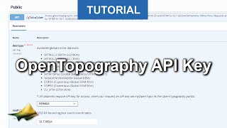
Using API Keys to Access OpenTopography’s Global Datasets API by OpenTopography 3,319 views 10 months ago 2 minutes, 40 seconds
Accessing & Processing Open USGS 3DEP Data on OpenTopography by OpenTopography 1,598 views 1 year ago 3 minutes, 41 seconds
Webinar: 3D Printing & iPhone Lidar by OpenTopography 2,544 views 1 year ago 51 minutes
Recommended
Home Truths Are Hard To Swallow NBA Edition
02:32
Where To Look For True Motivation
00:47
What Would You See Inside Spherical Mirror?
07:14
Treat Your Toys With Respect To Keep Your Pants Dry!
01:42
Megan Fox Unpacking Your Christmas Gifts!
14:32
Cops & Dads Have So Much In Common!
00:25
Best Easter Bunnies & Hens At Your Service For An Awesome Holiday
01:06
No Dogs? So What About SpotMini?
00:25
This Car Flip Could Hardly Look More Realistic!
04:02
Skiing & Other Disasters
08:01


![1 How to Set Up a New Project and Import DEM [GeoTiff] into ArcGIS Pro by OpenTopography 1,578 views 4 months ago 6 minutes, 13 seconds](https://i.ytimg.com/vi/H95kla74mcQ/mqdefault.jpg)