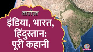
200 साल पहले कैसे बनाया गया India का नक्शा कहानी The Great Trigonometric Survey का | Tarikh Ep.746
Nain Singh: • ये भारतीय न होता तो दुनिया के नक़्शे प...
Everest: • Mount Everest के बारे में अंग्रेजों ...
Tarikh Episode 746
Tarikh is a daily program in which we present you with incidents and stories of noteworthy persons of Indian History in Hindi. In this edition of Tarikh, Nikhil talks about the great trigonometric survey. launched in 1802 by the British East India Company, transformed India's mapmaking. Pioneered by William Lambton, it used trigonometry to create a network of triangles across the subcontinent. Surveyors, braving harsh environments, meticulously measured angles between distant points. These measurements, combined with precise baseline distances, allowed them to calculate vast distances and elevations.
The Great Trigonometric Survey's impact was profound. It not only yielded accurate maps for navigation and development, but also measured the heights of Himalayan peaks, including Everest. It established a national reference system for future maps and surveys, and contributed to advancements in cartography, mathematics, and astronomy. This immense undertaking stands as a testament to human ingenuity and the enduring power of precision and collaboration in scientific discovery.
खबरों को विस्तार से पढ़ने के लिए क्लिक करे यहां https://www.thelallantop.com/
Instagram: / thelallantop
Facebook: / thelallantop
Twitter: / thelallantop
Produced By: The Lallantop
Edited By: Alok Sahu