2D HEC-RAS 5 Full Example/Tutorial from Civil 3D to HEC-RAS 5 to QGIS to Civil 3D

Greetings All,
This video shows you how to setup a Basic 2D HECRAS model from scratch along with exporting the results to use in CAD, in this example the results are exported to be used in Civil3D.
The Basic Steps I show in the video are as follows:
1. Georeferencing a Civil 3D Drawing;
2. Inserting a Bing Satellite Image into Civil 3D;
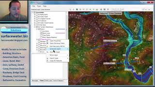
3. Creating a Civil 3D Surface and Exporting it as a DEM file;
4. Creating and exporting a Manning n value map in Civil 3D to be used in HECRAS as a Shapefile;
5. Setting up and running a Basic 2D HECRAS 5 model;
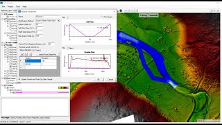
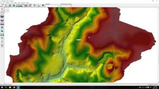
6. Viewing Results;
7. Exporting the results;
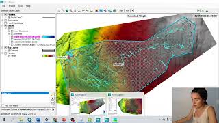
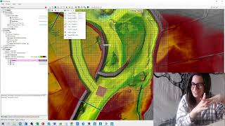
8. Importing the results in QGIS to develop contours and color graded images showing the flow velocity, water surface elevation and the inundation boundary;
9. Exporting the images as GEOTIFF files;
10. Exporting the contours as Shape Files; and
11. Importing and viewing the Shape and GEOTIFF files in Civil 3D.
Please note that I am no Expert in the software discussed and I don’t take any responsibility for the results you obtain. I don’t discuss any of the program settings in detail.
The accuracy of the results obtained from HECRAS can be improved significantly by tweaking some of the settings which isn’t discussed in this video.
I Hope this video helped you to get your model up and running and sort out some of the issues that you might pick up along the way.
If this video helped you in any way please feel free to Like, Share and Subscribe for any future videos I make.
Kind Regards,
Alto Roos
Link to HECRAS:
https://www.hec.usace.army.mil/softwa...
Link To QGIS:
https://qgis.org/en/site/forusers/dow...


![[HEC RAS 2D #3]ADD LATERAL STRUCUTRE | WEIR | LEVEE | 1D RIVER| BANKLINE | FlowPathLine | RAS MAPPER](https://i.ytimg.com/vi/jJAv7HEDTj0/mqdefault.jpg)