A Complete Beginner's Guide for QGIS 3 || QGIS for Beginners 2020 ||

In this QGIS Beginner's Series, we have done :
00:00 Downloading and Installation of QGIS latest version
08:20 Introduction to QGIS Interface
09:10 Manage and Install Plugin (with examples)
11:49 Dealing with Vector Files
17:27 Dealing with Excel File
17:39 Importing and Displaying XY coordinates (Feature Conversion Tools)
19:52 Styling, analyzing data and symbology of Vector Data
21:30 Dealing with Attribute table and calculating area without Geometry Tools
28:33 Basic of Digitization
29:30 Basic use of vector Data Management Tool
36:17 Introduction to Raster data
37:05 Raster Data basic handling part
47:00 Styling and symbology of Raster data.
49:05 Layout works and exporting of Map
Follow us on Social Media:
Facebook IDs : / bhuwon.paudell
/ bhuwan.paudel.739
Facebook Page: / geotechstudio
Twitter id: / bhuwanpaudel96
instagram ids: / iambhuwanpaudel
Link to other Videos:
An Absolute Guide for Beginners || Beginners Series For ArcGIS || Part 2 || @GeoTech Studio
• An Absolute Guide for Beginners || B...
Absolute Guide For ArcGIS Beginners || Beginner Series For ArcGIS || Part 1:
• Video
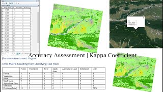
Accuracy Assessment || Kappa Coefficient || Overall Accuracy:
• Video
Equal Block Division based on Area:
• Video
DEM and LULC Data Preparation for SWAT Model :
• DEM and LULC Data Preparation for SWA...
Soil Map Preparation for SWAT Model :
• Soil Map Preparation for SWAT Model |...
Data Preparation SWAT Model : Soil Properties Data || SWAT Simulation:
• Data Preparation SWAT Model : Soil Pr...
Installation of ERDAS Imagine 2015:
• Video
Mosaicing in GIS:
• Mosaicing in GIS || Extraction of AOI...
Slope Analysis from DEM in ArcGIS:
• Slope Analysis from DEM in ArcGIS || ...
Digitization in QGIS Using Snapping Options
• Digitization in QGIS Using Snapping O...
Georeferencing on QGIS
• Georeferencing on QGIS || @GeoTech_St...
Hotspot Analysis Using ArcMap:
• Hotspot analysis using ArcGIS || Crim...
Stream Order Analysis from a Digital Elevation Model using ArcGIS 10.X
• Stream Order Analysis from a Digital ...
Extraction or Digitization of Land features using Landsat 8 Data:
• Extraction or Digitization of Land fe...
Calculating Land Surface Temperature using Landsat 8 images by ArcGIS:
• Extraction or Digitization of Land fe...
Calculating the Criteria Weight by Multiple Criteria Decision Making :
• Calculating the Criteria Weight by Mu...
Interpolation:
• Heat Distribution Mapping Using diffe...
Thematic Mapping of COVID19:
• Thematic Mapping of COVID 19 || Gener...
Study Area Mapping:
• Study Area Mapping Using ARCGIS ||10....
Landuse Land Cover link:
• Land Use Land Cover Mapping | Image C...
Landslide Assessment video link:
• How to do Landslide Analysis in Arcgi...
USGS data downloading tutorial video link:
• Download Dem or landsat data from Goo...
Fire Risk Assessment video link:
• Fire Risk Zonation or Assessment On A...
Water Delineation Tutorial link:
• How to use a DEM to delineate a Water...
Georeferencing On ArcMap:
• Georeferencing In ArcGIS (Bhuwan Paud...
Official Gmail ID: [email protected]
#QGIS_For_Beginners
#QGIStutorials
#QGIS_For_Beginners
#GeoTechStudio


![432hz [Tree of Life] Open all doors of abundance, remove all barriers, attract prosperous luck](https://i.ytimg.com/vi/jQWeQOajzmY/mqdefault.jpg)


![Beginner to TSQL [Full Course]](https://i.ytimg.com/vi/cACat4KNncg/mqdefault.jpg)


![HandsOn Power BI Tutorial Beginner to Pro [Full Course] ⚡](https://i.ytimg.com/vi/5X5LWcLtkzg/mqdefault.jpg)