A Guide to Downloading ALOS PALSAR DEM | 12.5 meter Resolution Elevation Data

Hi,
Welcome to Dawn of Geospatial World. Where you can learn about GIS, Remote sensing, Satellite Imageries.
About this Video
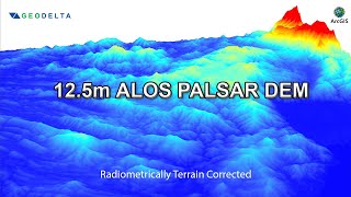
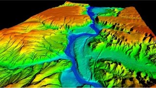
ALOS or Advanced Land Observing Satellite or Daichi was a satellite mission by JAXA, Japan. This mission was operated from 2006 to 2011. This satellite was carried 3 sensors named Panchromatic Remote Sensing Instrument for Stereo Mapping (PRISM), Phased Array type Lband Synthetic Aperture Radar (PALSAR) and Advanced Visible and Near Infrared Radiometer type2 (AVNIR2). Today we will learn to download PALSAR DEM data which has 12.5 meter resolution and radiometrically corrected.
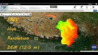
Althrough ALOS was a japanese Satellite Mission, but we can download it from JAXA & Alaska Satellite Facility website. For better understanding, I am showing from ASF.
Alaska Satellite Facility: https://asf.alaska.edu/datasets/sar...
Watch the full video for better understanding.
#gis #gis2023 #remotesensing #qgis #dem #arcgis #arcmap #elevation #education #dawnofgeospatialworld #digitalelevationmodel #jaxa #japan #japanese #usa #alaska #alaskasatellitefacility #datadownload #howto #alos #palsar #sar #syntheticapertureradar #microwave
Various Space Agencies & Missions: • Space Agencies & Earth Observing Miss...
Data Download Processes for GIS Work: • Download Data for GIS & Remote Sensin...
The following geospatial and environmental solutions video instruction is available on this channel:
ArcGIS, QGIS (Geospatial Analysis, Monitoring)
Cartography
Basics of Mapmaking
Basics of GIS & Remote Sensing
Google Earth Engine
You can watch our videos on YouTube : @dawnofgeospatialworld
If you think they're useful, kindly subscribe to our channel.
Follow us on Instagram : / dogw_official
Join our Facebook Group : / dogw.official
Thank you So Much.....