A Taste of the Appalachian Trail - Hiking u0026 Hammock Camping w/ the Amok Draumr 3.0 Hammock
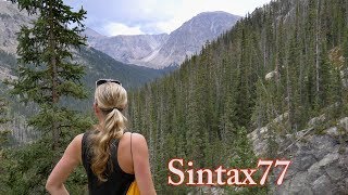
Join Sara & for some backpacking, hiking and hammock camping along the Appalachian Trail in Virginia's James River Face Wilderness. GPS Data at http://www.sintax77.com
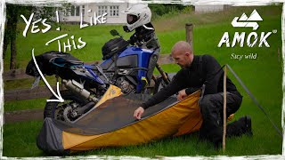
For this fall backpacking trip we'll be dipping into the world of the Appalachian Trail while testing out some new hammock camping gear most notably, the Amok Draumr 3.0 Hammock system details here http://amzn.to/2uj2qSx'>http://amzn.to/2uj2qSx ...
For an easier read with more details, check out my full blog post and trip report here: http://wp.me/p2ReUQeN
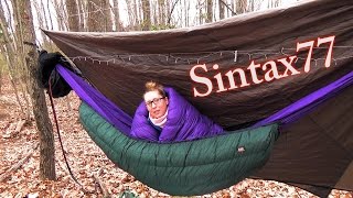
...The Draumr 3.0 is a rather unique flat hammock that I touched on in a previous video, 'Amok Draumr 3.0 – A Super Flat Hammock? – First Look'. As discussed in that video, the Draumr works in conjunction with an inflatable sleeping pad to create what is essentially a floating bed. It can also be used in a chair configuration for lounging at camp. In addition to testing out the Draumr, I'll be trying out some whoopie slings rigged up with some Dutch Whoopie Hooks. The hooks allowed for a really quick and simple way to attach and detach the whoopie slings to my trusty Darien Dream Hammock.
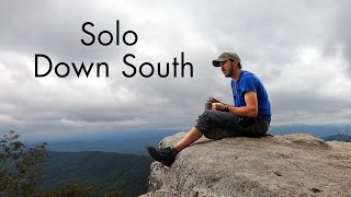
With our shelter and sleeping methods squared away, we were ready for some exploration of the east coast's most fabled long distance hiking path the Appalachian Trail, the "AT" as it's affectionately called by those of us who prefer a nice acronym now and the. While I've incorporated pieces of the AT into many of my trips before, this particular hike seemed to really capture the spirit and flavor of the Appalachian Trail.
Trailhead and Parking: James River Footbridge N37° 35.819' W79° 23.474'
The James River Face Wilderness Area is a protected area located within the Jefferson National Forest, about 1 hour north of Roanoke, Virginia.
Route Taken and Trails Used, Day One
Cross the James River Foot Bridge
Turn left to continue following the AT.
The trail will eventually turn away from the river and and head deeper into the woods,following along Matt's Creek.
Arrive at Matt's Creek Shelter for a snack break at the picnic bench, and an entertaining peek at the shelter log.
Head up the ridge to continue on the Appalachian Trail
5 miles into the hike there will be a decent lunch spot (marked in my GPS data) with a nice, flat sunny area for lounging before ascending further up the the ridge. This spot was also the last flowing water source we encountered for the rest of the day. If you plan to camp up on the ridge in the same area that we did, make sure to stock up on enough water for the rest of the day, as well as tomorrow for breakfast and the hike out, to be safe.
Continue on the AT until arriving at the three way junction with Balcony Falls Trail and Sulphur Springs Trail.
Continue along the Sulphur Springs trail for a little less than a mile.
Camp at the site listed in my GPS Data.
Day 1 Total Mileage: 6.8 Miles
Day 1 Total Elevation Gain: 2,297'
Route Taken and Trails Used, Day Two
We chose to immediately start our day back on our old friend, the AT. This was possible by doing a very small "bushwack" west from the campsite until you run into the adjacent campsite then head south on the AT by turning left.
Continue along the AT until you hit the triple junction with Sulphur Springs, the AT and Piney Ridge Trail.
Head down the Piney Ridge Trail, towards Hunt Club Road, which will eventually bring you to Rt 501 Lee Jackson Highway.
Turn left (north) to do a road hike along Lee Jackson Hwy for a short bit.
We chose to make a more e
xpedient route back to the car, by continuing to walk along the road, over the auto bridge's pedestrian sidewalk. This route gave us a pretty cool view of the man made waterfall, as well as an alternate view of the rail trestle and footbridge that we had traveled over the previous day.
Arrive back at the Jame River Foot Bridge Parking lot and prepare yourself for cheeseburger time.
Day 2 Total Mileage: 8 Miles
Day 2 Total Elevation Gain: 486'
Trip Mileage Grand Total: 14.8 Miles
Trip Elevation Gain Grand Total: 2,783'
Notable Gear Used for Sara:
Dream Hammock Darien Ultralight Hammock w/ Whoopie Slings Dutch Whoopie Hooks
Hammock Gear Cuben Hex Tarp
Hammock Gear Burrow 20° Top Quilt
Hammock Gear Phoenix 30° Underquilt (3/4 length)
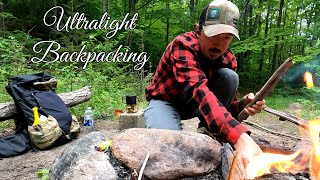
ULA Ohm 2.0 Backpack
Thorfire BD04 USB rechargable LED Flashlight http://amzn.to/2h3W1Eh
Princeton Tech Byte Headlamp http://amzn.to/2h2Tpqu
ThruNite Titanium Keychain LED Flashlight http://amzn.to/2uYiB70
EMS Knitted Hat
Notable Gear Used for Shawn:
Amok Draumr 3.0 Hammock http://amzn.to/2uj2qSx'>http://amzn.to/2uj2qSx See my first look video on it, or check out the Amazon link for full info.
Amok Stock Tarp for use with Draumr Hammock (30D Ripstop Nylon) http://amzn.to/2vcy3Mr
Hammock Gear Burrow 40° Top Quilt
Hammock Gear Incubator 40° Underquilt w/ Epsilon 1.5 Multicam Fabric
EMS Longtrail 70 Backpack
4Sevens Preon 2 LED Flashlight http://amzn.to/2h3fapY
Fenix HL21 Headlamp http://amzn.to/2uy9XLD
Generic Canister Stove http://amzn.to/2h3mRMY