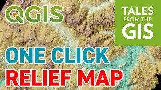
Acquisition and utilization of free Digital Elevation Model data: Carto DEM SRTM and ALOS part-1

Our website link: https://theqgeo.com/
For Our Face book Page: / qgeo114009753586443
Quiz link: at the end of 2nd part of the video.
The video highlights the Acquisition and utilization of free Digital Elevation Model data: Carto DEM, SRTM, and ALOS.
The video also describes the acquisition of data from the OpenDEM portal which is globalready to use contour data set in shape format.
Dear students, Scholars, and faculties of different colleges and universities, Please be noticed that there will be a minor correction in "CartoDEM= Cartosat 1 DEM, IRSO, India" in place of IRSO it will be ISRO.
I hope, it will be helpful for the students and scholars of Geography and the branch of subject GIS & RS with too much extent.
I am really thankful and convey my regards to all the Authors & Publishers in online and offline platforms from where I have collected information for making the video.
Background Sound Source: RoyaltyFree Music from https://www.zapsplat.com/ music_zapsplat_breaking_boundaries & Intro Maker app Part of the introduction has been created by the Intro Maker app on a mobile phone.


![The moment we stopped understanding AI [AlexNet]](https://i.ytimg.com/vi/UZDiGooFs54/mqdefault.jpg)