Add Google Satellite Map to QGIS | Google Satellite Images

Link to the All videos: https://agrimetsoft.com/qgis_tutorial
QGIS Tutorial on YouTube: https://bit.ly/35zXNDS
Add #Google_Satellite Map to #QGIS
===
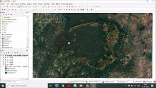
In this video, you have a real quick tutorial for how to add google satellite images to QGIS. Google satellite images can do a lot in terms of recognizing, locating, and classifying features and maps. If you add those maps to the QGIS interface, you can browse them online. In order to add google satellite images, first, click on the plugins option then go for manage and install plugins. In the search box, type quick map services. When it is shown, then you can install and find it in the web option! That’s all! Watch the video to see exactly how to add Google Maps images to your QGIS software.
Tags:
add google #satellite_map to qgis,qgis tutorial,qgis maps,qgis import maps,google maps qgis,qgis google maps,qgis add basemaps,qgis for beginners,how to add google map in qgis,google map in qgis,bing maps qgis,qgis bing maps,add maps to qgis,maps for qgis,qgis tutorials for beginners,add google satellite map in qgis,use google satellite in qgis,add google satellite to qgis,qgis google maps layer,qgis google maps plugin,define projection qgis google maps