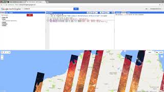
Adding Landsat Data into Google Earth Engine

Link to code: https://code.earthengine.google.com/0...
Purpose: The purpose of this lab is to enable you to search and find remotely sensed imagery in Google Earth Engine. Searching (and finding) Landsat.
Landsat is a NASA program that has launched a sequence of Earth observation satellites, named Landsat 1, 2,... etc. Note that the Landsat program has resulted in the longest continuous observation of the Earth's surface. In this exercise, you will load a Landsat scene over your area of interest, inspect the units and make a plot of radiance. Specifically, use imagery from the Landsat 8, the most recent of the sequence of Landsat satellites (Links to an external site.)Links to an external site. To inspect a Landsat 8 image (also called a scene) in your region of interest (ROI), define your ROI as a point, filter the image collection to get a scene with few clouds, display some information about the image in the console.
More Videos: https://sounny.github.io/