Advanced editing in QGIS | burdGIS

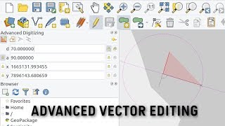
Welcome back, map enthusiasts! Today, we're diving into advanced editing techniques in QGIS, using a realworld scenario in Sunny Doncaster. In this tutorial, we'll guide you through creating precise landscape buffers and using advanced digitizing tools. Download the practice data and helpful PDF guide from the link below and follow along as we explore:
00:00 Intro and practice data
00:16 Selecting and zooming to features in the attribute table
00:52 Creating and setting up a temporary scratch layer
01:31 Adding and configuring toolbars for advanced digitizing and snapping
02:53 Using construction mode, distance, and angle settings
05:21 Drawing and snapping polygons with exact measurements
09:44 Join the waiting list for a new course and receive a discount on the course price
Whether you're working on urban planning, environmental projects, or just honing your GIS skills, this video has you covered. Don't forget to like, comment, and subscribe for more GIS tutorials!
Links:
Practice Data & PDF Guide: https://docs.google.com/forms/d/e/1FA...'>https://docs.google.com/forms/d/e/1FA...
Contaminated Land Course Interest Form: https://docs.google.com/forms/d/e/1FA...'>https://docs.google.com/forms/d/e/1FA...
Follow us for more GIS insights and updates!
Like and share if you found this video helpful!
If you enjoyed this video you can support the channel and buy me a coffee using this link:
https://paypal.me/burdGIS
Visit our site
https://www.burdgis.com
Take an online GIS course
https://www.udemy.com/course/anintro...
Find us on facebook
/ burdgis
Use coinbase as the home for your cryptocurrency:
https://www.coinbase.com/join/5c6d098...


![How to use Zotero's full potential [The AI Revolution in Zotero]](https://i.ytimg.com/vi/gA3o2MlnPBQ/mqdefault.jpg)