Sign In
Home
Popular
News
Popular now
New music
Cute animals
Trending today
Hot trailers
Popular music
Comedy clips
New tech
Popular sports
Learn new
Get YouTube subscribers that watch and like your videos
Animals
Babies
Beautiful
Cats
Creative
Cute
Dogs
Educational
Funny
Heartwarming
Holidays
Incredible
Inspirational
Interesting
Love
Music
Nature
Oops
Performance
Pranks
Science
Sports
Technology
Unexpected
Cat Cartoons
Dog Humor
Cover Song Contest
Air Quality Mapping using QGIS point PM2.5 value
Back
Follow
https://openaq.org/#/countries?_k=dmlk2k
posted by
beyondjdrew56
[ f ] Share this video on Facebook
How to solve Invalid Topology using Repair Geometry tool if your clip is not working
NASA ARSET: Overview of Remote Sensing Observations to Assess Water Quality, Part 1/3
Using QGIS to Interpolate Air Pollution Sampling Points using IDW
Download Air Quality Data using Giovanni NASA Earth Data Free
R Statistical Language openair Package
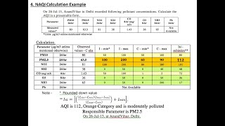
Air Quality Index Calculation
Spatial Interpolation Techniques in QGIS
Blender, QGIS & Digital Elevation Maps
Applications of Remote Sensing to Air Quality Monitoring By Dr. Nazmi Saleous
The $64M Race to Save the Eiffel Tower
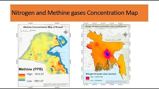
How to make airquality Mapping using Remote sensing | Nitrogen and Methine gase Concentration Map
QGIS Flood Risk Mapping Walkthrough
Inverse Distance Weighting (IDW) in QGIS using Air Quality Index Sampling Points of MMR
Delineation of Groundwater Potential Zones Using GIS/Remote sensing Techniques and AHP
Download Air Quality Data from Earth Data || NASA Earth Data
Deriving River Network & Catchments from a DEM using QGIS
Making 3D Maps of Air Pollution in ArcGIS
Introduction to the InVEST Seasonal Water Yield
Recommended
Puppies VS New Star Wars BB-8 Droid Toy: Who's More Adorable?
01:02
How Coaches wanna act when their star player gets tired
01:34
Is This Reall Christmas Movie?
13:11
50 Shades Of Doug The Pug
00:26
What Happens To Your Body When You Stop Eating?
03:31
No Planes No Gains?
01:49
This Is Exactly What Every Hotel Is Like
05:09