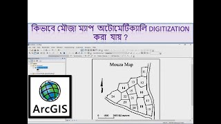
ArcGIS Digitization Creation of Shapefile in Arc GIS
This tutorial will help you to do creating shapefile and digitization of Polygon, Line and Point Feature in Topographical Map Using Arc GIS software. This is complete tutorial for digitizing of initial topographical mapping with lots of information. It is an important GIS technique for analysis of different planning and development processes.
#polygon_feature
#Line_feature
#Point_feature
#Digitization
#Shapefile
#Topographical_map
#Software
#GIS
#GIS_Software
#QGIS
#qgis #arcgis
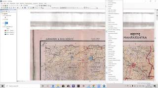
Link of Image to image georeferencing: • How to do Image to Image Georeferenci...
Link of Raster image georeferencing: https://www.youtube.com/watch?v=sf95m...
Link of Raster image digitization: https://www.youtube.com/watch?v=shnkV...
Choropleth Map Preparation using QGIS 2020: • How to prepare a Choropleth Map Prepa...
NDVI Calculation: • How to do NDVI Calculation in QGIS II...
Follow the Link for more videos:
• Video
• How to Geo Referencing of Topographic...
• How to create Thiessen Polygons in QG...
• How to merge overlapped Landsat Band...
• How to Create River and City Points M...
• How to Create Multiple Buffer Zone in...
• Change Detection Analysis of Land use...
• Change Detection Analysis of Land use...
• How to download Land use and Land cov...
• Accuracy assessment of Landuse and La...
• How to download District River, Road,...
• How to download World Shape file and ...
• How to create 3D Model of DEM image u...
• Land Use Land Cover Map of Landsat 8 ...
• How to create DEM from Google Earth I...
• How to create DEM (Elevation Map) an...
• How to create Contour line and DEM (E...
Contact: [email protected]