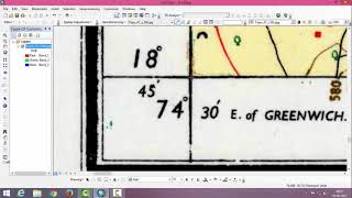
ArcGIS Georeference Clip Mosaic and extracting project area from toposheet using shape file.

0:00 0:11 selection of toposheet
0:11 0:27 selection of geographic coordination system
of your study area
0:27 4:30 Georeferencing of given toposheet and
Rectifying the toposheet
4:30 6:47 Clip tool, Clipping the toposheet to remove
outer part of toposheet
6:47 7:27 Add all toposheet of your study area
7:27 9:50 Mosaic tool, Merging all topisheet into one
toposheet
10:00 10:36 Add shape file of your study area
10:39 10:45 Add Editor tool
10:45 12:52 Extract your study area from toposheet
using shape file, use clip tool. Any shape
we can clip.
In this video lesson, we will learn how to Georeferencing Survey Of India Toposheet using ESRI's ArcGIS Software and add georeferenced image
Scanned paper maps, drawings or maps found online may contain useful information not found elsewhere. GIS allows us to georeference a map to link the image its corresponding location. This video tutorial shows the steps to complete the georeferencing of a map with ArcGIS.