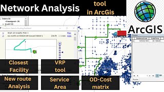
Arcgis new route analysis | Network analysis

data for network analysis in arcgis.
https://drive.google.com/drive/folder...
arcgis new route analysis.
Hello everyone! Welcome to my video on route analysis in ArcGIS.
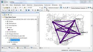
network analysis arcmap.
In this tutorial, we’ll be discussing arcgis network analysis the basics of route analysis, and how it can be used to determine a variety of routes including the shortest and quickest options.
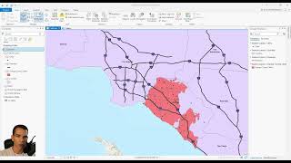
Route analysis is a helpful tool when it comes to finding the most efficient way to get from point A to point B. It can be used in a variety of ways and for a variety of purposes, such as identifying routes with the least amount of traffic or the most scenic route.
In this tutorial, we’ll be focusing on finding the shortest and quickest routes. To begin, we’ll need a few things: data with street and/or road information, geographic points of the starting and ending locations, and a network dataset.
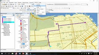
Once we have our data, we need to create a route layer. A route layer can be created in ArcGIS by going to the 'Analysis' tab and clicking 'New Route Layer'.
arcgis route analysis Tutorial
Once the route layer has been created, we’ll need to define the route parameters, such as what type of route we’re looking for (shortest or quickest), the impedance (such as distance or time), and any route restrictions (such as oneway streets).
arcgis network analysis tutorial.
Once these settings are configured, we can finally start to analyze our route. First, we’ll need to define our locations by marking our points of origin and destination. Then, we can select the route that we want to analyze.
how to do network analysis in gis.
Once the route is selected, we can click the 'Solve' button to generate a route between the two points. The route that is generated will be the route that is either the shortest or quickest, depending on the parameters we set.
We can also click on the 'Evaluate' button to see additional information about the route, such as its length, the estimated travel time, and the direction of turns.
And that’s it! That’s how you can use route analysis in ArcGIS to find the shortest and quickest routes. Thanks for watching!
#shortest #route #arcgis #networkanalyst