ARC-GIS Tutorial

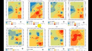
This tutorial by Sooraj S, Senior Geologist, State Unit: Chhattisgarh, Geological Survey of India will enable you to operate ARCGIS for contouring of any data set (specially chemical/geochemical data) and obtain reliable result. Please watch the full tutorial to learn step wise in detail. First the manual method is demonstrated followed by automatic Batch Contouring using a custom toolbar. The link is
******************************************************************
https://github.com/soorajgeo/Geochemi...
******************************************************************
Hope after watching this tutorial you will be able to generate satisfactory contour maps of geochemical data.
******************************************************************************
Link of our other videos:
1. • Introduction of Geological Survey of ...
2. • Measurement of strike, true dip of an...
3. • ASTER DATA PROCESSING (PART1) USING ...
4. • Structural Geology Practical (PART1)...
5. • Structural Geology Practical (PART2)...
Our aim is to spread geology, geophysics, geochemistry and Earth Science related knowledge among mass for free and build up a strong geoscience community.


![The moment we stopped understanding AI [AlexNet]](https://i.ytimg.com/vi/UZDiGooFs54/mqdefault.jpg)