Automated LULC CROP Classification Sentinel Data USING GEE : Crop Classification Google Earth Engine

Mapping Urban Areas, Water Bodies, Vegetation, and Rice Paddies in Maguindanao with Earth Engine:
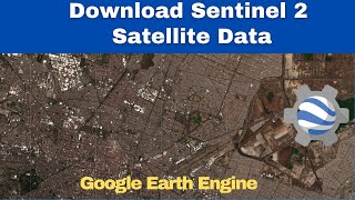
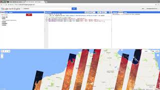
Loading Sentinel2 and Sentinel1 Data: To begin, I loaded data from both Sentinel2 and Sentinel1 satellites. These datasets are invaluable for monitoring changes on the Earth's surface over time.
Defining the Time Period and Area of Interest (AOI): Next, I specified the time frame and geographical area that I wanted to analyze. This helps narrow down the focus of the study to a specific region and timeframe.
Filtering Sentinel2 and Sentinel1 Data: After setting the parameters, I filtered the Sentinel2 and Sentinel1 datasets to only include the data within the defined AOI and time period. This ensures that we're working with relevant data for our analysis.
Cloud Removal for Sentinel2 Imagery: Cloud cover can obscure the Earth's surface in satellite imagery, so I developed a method to remove clouds from the Sentinel2 images. This ensures clearer and more accurate analysis results.
Calculating Indices: Using the filtered Sentinel2 imagery, I calculated several indices such as NDBI, NDVI, and NDWI. These indices provide valuable insights into land cover types, including urban areas, water bodies, and vegetation.
Defining Thresholds for Land Cover Identification: Based on the calculated indices, I established thresholds to identify different land cover types like urban areas, water bodies, and vegetation. This step helps automate the classification process.
Calculating Area of Different Land Cover Types: With the thresholds in place, I quantified the area of various land cover types within the AOI. This includes urban areas, water bodies, vegetation, and specifically, rice fields.
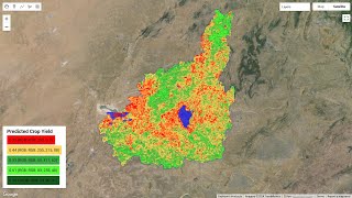
Visualizing Identified Areas on a Map: To better understand the results, I created a map displaying the identified urban areas, water bodies, vegetation, and rice fields. Visualization aids in interpretation and communication of the findings.
Printing the Calculated Areas: Finally, I printed out the calculated areas of each land cover type. This provides concrete figures that can be used for further analysis or reporting purposes.
In summary, the process involved loading, filtering, analyzing, and visualizing Sentinel satellite data to assess land cover types and specifically identify rice fields within a defined geographic area and time period.
#Cloud Masking, Median Image Compositing, and Thresholding for Land Cover Mapping in Earth Engine
#Leveraging Sentinel1 and Sentinel2 Data to Quantify Land Cover Types in Maguindanao
#Earth Engine, #Remote Sensing, #Satellite Imagery, #Land Cover Classification, #Sentinel1, #Sentinel2, #GIS, #Pakistan, #Maguindanao, #Land Use, #Urbanization, #Water Resources, #Vegetation Mapping, #Agriculture, #Rice Paddies, #Environmental Monitoring, #Geography
#NDVI, #NDWI, #NDBI, #Cloud Masking, #Median Composite, #Thresholding, #Land Cover Change, #Urban Expansion, #Water Body Detection, #Forest Mapping, #Paddy Field Identification, #Land Management, #Sustainable Development, #Climate Change, #Food Security, #Drones, #UAVs, #Precision Agriculture, #Artificial Intelligence, #Machine Learning
#GIS Tutorial, #Earth Engine Tutorial, #Remote Sensing Tutorial, #Free Data, #Open Source, #Data Analysis, #Science Communication, #Environmental Science, #Geography Education, #Agriculture Technology, #Pakistan Tech, #Drone Mapping, #Nature Photography, #Satellite Images, #How To, #EarthEngine #RemoteSensing #SatelliteImagery #LandCoverClassification #Sentinel1 #Sentinel2 #GIS #Pakistan #Maguindanao #LandUse #Urbanization #WaterResources #VegetationMapping #Agriculture #RicePaddies #EnvironmentalMonitoring, #NDVI #NDWI #NDBI #CloudMasking ☁ #MedianComposite #Thresholding #LandCoverChange #UrbanExpansion #WaterBodyDetection #ForestMapping #PaddyFieldIdentification #LandManagement #SustainableDevelopment ♻ #ClimateChange #FoodSecurity #Drones #UAVs #PrecisionAgriculture #AI #MachineLearning, #GISTutorial #RemoteSensingTutorial #FreeData #OpenSource #DataAnalysis #ScienceCommunication #EnvironmentalScience #GeographyEducation #AgricultureTechnology #PakistanTech #DroneMapping #NaturePhotography #SatelliteImages #HowTo, #AmazingDiscoveries #SecretTechniques #UnbelievableResults #PakistaniAgriculture #MaguindanaoSecrets #EarthFromAbove #SeeTheUnseen #FutureOfFarming #GreenTechnology ♻ #DroneRevolution.