Automatic LiDAR Reclassification in Global Mapper

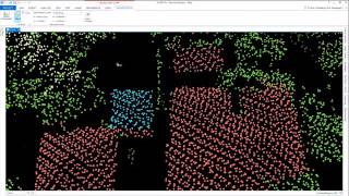
In the fourth webcast in the LiDAR Processing series, we show the procedure for improving the usability of LiDAR by flagging noise points and identifying points that represent specific surface types. Foremost in this automatic reclassification process is the detection of ground points in unclassified data, which is a prerequisite for creating a DTM. We also walk through the process of identifying and reclassifying buildings, trees, and power lines based on their geometric properties.
If you have questions about any of the workflows or topics covered in this presentation, email: [email protected].
For licensing or sales questions, email [email protected].
To download an evaluation copy of Global Mapper, visit: www.bluemarblegeo.com/products/globalmapper.php