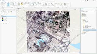
Automatic Road Extraction From Aerial Photographs/Satellite Imagery Using ArcGIS Pro Part 1

Automatic Road Extraction From Aerial Photographs/Satellite Imagery Using ArcGIS Pro Part 1. Apply the finished model to extract the road network in raster format.
This video is the first part of the few videos about how to extract road network from satellite imagery / aerial photographs in ArcGIS Pro.
Finished DLPK model can be downloaded from : https://www.arcgis.com/home/item.html...
ArcGIS Pro Deep Learning Libraries can be downloaded from : https://github.com/Esri/deeplearning...
Second Video already uploaded here: • Automatic Road Extraction From Satell...
Music by : www.bensound.com
#arcgis #arcgispro #deeplearning #AI #machinelearning #geospatial #geoai #roadmapping #roadextraction #roadnetworkmapping #gis #geographicinformationsystem