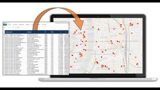
Basic Concept of Geocoding in ArcGIS

Geocoding is the process of taking a textbased description of a location, such as an address or the name of a place, and returning geographic coordinates, frequently latitude/longitude pair, to identify a location on the Earth's surface.
In this Video You will know basic of geocoding in arcgis.
If you are interested in the downloading the dem data from Qgis
• Dem data download in QGIS
If you are interested in loading the different basemaps in Qgis • How to add different basemaps in Qgis
How we can visualize the COVID 19 patient using web maps.
• How we can visualize the COVID 19 pat...
How to find the UTM zone of your data which is in Geographic coordinate system in ArcGIS
• How to find the UTM zone of your data...
How to make the raster image of the Higher Resolution from low resolution(30 M Landsat to 15 M )
• How to make the raster image of the H...
Downloading the Landsat data of the specific bands and of required area of interest.
• Downloading the landsat data of the s...
Calculating the Area of the Raster data in ArcGIS
• Calculating the Area of the Raster da...