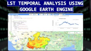
Calculate LST Time Series Multiple Areas using Google Earth Engine : Pakistan's Provinces LST.

Exploring Land Surface Temperature Variation Across Pakistan's Provinces
Hey everyone, welcome back to our journey of exploring geographical phenomena using Google Earth Engine. In this video, we delve into the fascinating realm of Land Surface Temperature (LST) variations across Pakistan's provinces over the years.
To begin our analysis, I first define a list of years ranging from 1991 to 2021, allowing us to observe changes in LST over time. Next, I load the Area of Interest (AOI) delineating Pakistan's provincial boundaries, utilizing the powerful capabilities of Google Earth Engine.
Once our AOI is set, we leverage Landsat satellite imagery collections, including Landsat 4, 5, 7, 8, and 9, to gather data on Land Surface Temperature. Employing a composite function, I filter and process the satellite images for each year and province, ensuring accurate representation of LST.
Throughout the process, I implement cloud masking techniques tailored to different Landsat sensors to minimize interference from atmospheric conditions, guaranteeing the reliability of our LST data.
As the imagery is processed and visualized on the map, we witness the dynamic changes in Land Surface Temperature across Pakistan's diverse provinces, from the mountainous terrains of Gilgit Baltistan to the arid landscapes of Balochistan.
Additionally, I calculate the average LST for each province over fiveyear intervals, providing valuable insights into longterm temperature trends and regional variations.
Finally, I present our findings through interactive charts, enabling a deeper understanding of how Land Surface Temperature evolves across Pakistan's provinces over time. From these visualizations, we can discern patterns, anomalies, and potentially uncover valuable information for various applications, including agriculture, urban planning, and environmental monitoring.
Join me on this exciting journey as we unravel the intricate relationship between Land Surface Temperature and geographical dynamics in Pakistan's diverse landscape.
Stay tuned for more exciting explorations in geography, remote sensing, and GIS with AI. Don't forget to like, share, and subscribe for more insightful content. Until next time, happy exploring!


![FULL COURSE Google Earth Engine Python API and Colab for Absolute Beginners in 3 Hours [2023]](https://i.ytimg.com/vi/Lqirs04EccA/mqdefault.jpg)