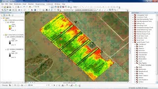
Calculate NDVI with QGIS v3.4

The NDVI (Normalized Difference Vegetation Index) is a versatile vegetation index to evaluate the vegetation and dynamic of the vegetation coverage change. This index has been studied and evaluated with many satellites over the years, changing its calculus method in relation to the number and type of bands of the satellite. This video shows how to apply the NDVI to Landsat8 images using QGIS.
Landsat8 Operational Land Imager (OLI) and Thermal Infrared Sensor (TIRS) images consist of nine spectral bands with a spatial resolution of 30 meters for Bands 1 to 7 and 9. The ultra blue Band 1 is useful for coastal and aerosol studies. Band 9 is useful for cirrus cloud detection. The resolution for Band 8 (panchromatic) is 15 meters. Thermal bands 10 and 11 are useful in providing more accurate surface temperatures and are collected at 100 meters.
References:
https://www.qgis.org/en/site/
https://libra.developmentseed.org/
https://landsat.usgs.gov/whatareban...


![How to make your own location map in QGIS [Spanish and English subtitles]](https://i.ytimg.com/vi/_rlKenxKMrI/mqdefault.jpg)