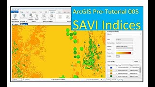
Calculate SAVI using Google Earth Engine

In this Tutorial, I will present how to calculate Soil Adjusted Vegetation Index by using Google Earth Engine
SAVI is used to correct Normalized Difference Vegetation Index (NDVI) for the influence of soil brightness in areas where vegetative cover is low. Landsat Surface Reflectancederived SAVI is calculated as a ratio between the R and NIR values with a soil brightness correction factor (L) defined as 0.5 to accommodate most land cover types.
((NIR R) / (NIR + R + L)) * (1 + L)
In Landsat 47, SAVI = ((Band 4 – Band 3) / (Band 4 + Band 3 + 0.5)) * (1.5).
In Landsat 89, SAVI = ((Band 5 – Band 4) / (Band 5 + Band 4 + 0.5)) * (1.5)
The SoilAdjusted Vegetation Index (SAVI) is a vegetation index that attempts to minimize soil brightness influences using a soilbrightness correction factor. This is often used in arid regions where vegetative cover is low.
NIR and Red refer to the bands associated with those wavelengths. The L value varies depending on the amount of green vegetative cover. Generally, in areas with no green vegetation cover, L=1; in areas of moderate green vegetative cover, L=0.5; and in areas with very high vegetation cover, L=0 (which is equivalent to the NDVI method). This index outputs values between 1.0 and 1.0.
#gee
#SAVI
#savi
#remotesensing
#gis
#spectralindices