Calculating vegetation indices u0026 plant/soil separation with QGIS (Drones in agriculture series 3/7)

In this video, we run through the steps of how to calculate vegetation indices based on RGB imagery, and then how to use this to create a classification layer that separates plants from soil and is useful for segmentation.
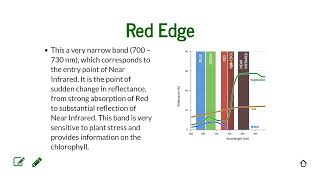
The equation for Excess Green is:
2 * (Green / (Red + Green + Blue)) – (Red / (Red + Green + Blue)) – (Blue / (Red + Green + Blue))
There are other vegetation indices that may be useful, such as VARI:
(Green Red) / (Green + Red Blue)
If you found these methods useful, please consider citing our recent paper in the journal Remote Sensing:
Parker, T. A., Palkovic, A., & Gepts, P. (2020). Determining the Genetic Control of Common Bean EarlyGrowth Rate Using Unmanned Aerial Vehicles. Remote Sensing, 12(11), 1748.