Secret sauce that brings YouTube followers, views, likes

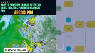
Change detection in ArcGIS Pro

Change detection is one of the fundamental applications in imagery and remote sensing. It is the comparison of multiple raster datasets, typically collected for one area at different times, to determine the type, magnitude, and location of change. Change can occur because of anthropogenic activity, abrupt natural disturbances, or longterm climatological or environmental trends.
The output from change detection is a difference raster where each pixel contains the type or magnitude of change.
When comparing thematic landcover rasters, the result contains information about the type of change that occurred.
More read link: https://pro.arcgis.com/en/proapp/lat...


Recommended