Clip Multiple Landsat 8 Bands with Python and GDAL - Tutorial

The use of programming / processing languages like Python and advanced spatial libraries as GDAL (gdal.org) helps on the spatial data transformation on a more abstract and effective way. This tutorial shows the complete procedure to clip the complete set of bands from a Landsat 8 image and store them with a suffix on every band file on another folder.
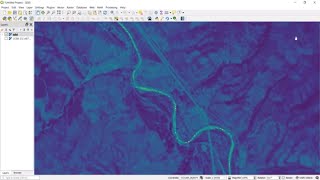
The tutorial is done on a interactive Python programming platform called Jupyter Notebook. The input files: raster bands and area of interest (AOI) shapefile need to be on the same system of reference (SRC), otherwise the GDAL library cannot locate the spatial data on the right position. The tutorial shows the procedure for the whole set of band form a Landsat 8 image, an example for a single band is provided on the scripts of the input data. Finally the tutorial shows the complete and clipped raster on a GIS desktop software as QGIS.
Input data
You can download the input data and scripts for the tutorial on this link:
https://www.hatarilabs.com/ihen/clip...