Get YouTube subscribers that watch and like your videos

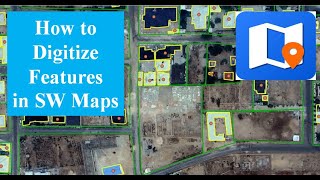
Collect GPS data using Mobile Phone || GPS survey using SW maps

#MobileGPS #SWmaps #GpsSurvey
This video demonstrate the method of collecting the GPS data using you smart phone with the help of SW maps software developed by Softwel.
▬ Contents of this video ▬▬▬▬▬▬▬▬▬▬
0:00 Introduction
1:07 Recording Polygon
3:12 Recording Track
4:33 Recording Point
5:00 Exporting shape files from SW maps
▬▬▬▬▬▬▬▬▬▬▬▬▬▬▬▬▬▬▬▬▬▬
These data can be used for:
preparation of study area map.
alignment survey of existing road, irrigation canal, river.
rough area calculation of land.
save and share the route while trekking.
Instructor:
Mousam Bhandari
B.E. in Civil Engineering, M.Sc. in Water Resources Engineering


Recommended