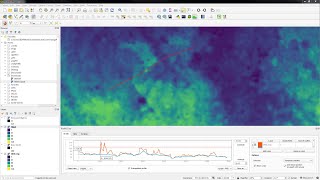
Compare Raster DEMs Contours and Point Clouds with the Elevation Profile Tool in QGIS

There's a new Elevation Profile Tool available from QGIS 3.26. In this video we explore how to compare raster DTM's, contour lines and a point cloud for different transects.
QGIS version: 3.26
Open data:
AHN3 via PDOK https://app.pdok.nl/ahn3downloadpage/
SRTM30 and NASA DEM via OpenTopography DEM Downloader plugin
A more detailed video by Nyall Dawson can be found here: • QGIS elevation profile/cross section ...
More information about the new features in this blog from Lutra Consulting: https://www.lutraconsulting.co.uk/blo...
There was also a session with the developers on the QGIS Open Day of May 2022: • New 3D and point cloud features in QG...
Do you want to learn more about point cloud processing and 3D visualization in QGIS? Enroll for my course at @udemy : https://www.udemy.com/course/qgispoi...
#QGIS #pointcloud #3d


![[QGIS] CREATING CONTOUR IN QGIS](https://i.ytimg.com/vi/SBgrKTE7EY8/mqdefault.jpg)