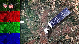
Composite Landsat 8 Band u0026 Pan sharpening Image in ArcGIS

some common band combinations applied to Landsat 8
Udemy course at ₹499 from (22 29 Oct 2022) Link: https://cutt.ly/qBMXjFu
******************************************************************
You can CHECK this OUT !!
BUY Domain at Cheap Price!! : https://cutt.ly/5CEuzSD
GIS Work|| Best laptop at Low cost!!
Acer Predator Helios: https://amzn.to/3MzpjWM
ASUS TUF Gaming: https://amzn.to/3CwUpti
Lenovo Legion: https://amzn.to/3g87HEW
MSI Stealth: https://amzn.to/3CX9qWH
MSI GV15: https://amzn.to/3EHtSfM
Acer Nitro: https://amzn.to/3CBJLSh
******************************************************************
For landsat 8 band understanding visit :https://openweather.co.uk/blog/post
/satelliteimagerylandsat8anditsbandcombinations
Natural Color : 4 3 2
False Color (urban) :7 6 4
Color Infrared (vegetation): 5 4 3
Agriculture: 6 5 2
Atmospheric Penetration : 7 6 5
Healthy Vegetation: 5 6 2
Land/Water: 5 6 4
Natural With Atmospheric Removal: 7 5 3
Shortwave Infrared: 7 5 4
Vegetation Analysis: 6 5 4
Composite Landsat 8 Band Arcgis
Pan sharpening in Arcgis
#Exploretutorials #Band_Composition #Pansharpen #ArcGIS
*****Important Tutorials ******
ArcGIS Geodatabase Design Basic File Geodatabase, Field, Subtype, Domain: https://cutt.ly/JYSmgQa
Free Spatial Data |Shapefile| of Any Country & Humanitarian Data: https://cutt.ly/1WawYD1
Land Cover Data 10 m Resolution: https://cutt.ly/3Waqcvo
Least Cost Path: https://cutt.ly/xWaqmEb
Download Open street Map: https://cutt.ly/SWaqWFk
Stream Power Index SPI Calculation:https://cutt.ly/jWaqT9t
Topographic Wetness Index TWI Calculation: https://cutt.ly/qWaqIw5
Suitability Analysis Using Arcgis: https://cutt.ly/6WaqSnA
Add xy data from excel, clip, select, split, table select tools in ArcGIS: https://cutt.ly/mWaqGuS
Drainage or Stream Frequency & Infiltration number: https://cutt.ly/7WaqJ5U
Calculate Stream or Drainage Density: https://cutt.ly/VWaqX36
Extracting Stream or Drainage Network from DEM: https://cutt.ly/QWaqMS9
Detail Watershed Delineation using DEM: https://cutt.ly/TWaq3Lk
ArcGIS Tutorial:https://cutt.ly/qWaq7gu
Qgis Tutorial: https://cutt.ly/ZWaq6e2
Change Detection: https://cutt.ly/sWawwfX
Download Free Shapefile:https://cutt.ly/XWawrsG
Download Soil Organic Carbon, Evapotranspiration, Land cover, Precipitation Data: https://cutt.ly/cWawtFC
Human Influence Calculation: https://cutt.ly/TWawuPv
Lineaments Extraction :https://cutt.ly/sWawi3K
World Soil Map Shapefile: https://cutt.ly/tWawaxY
Hotspot / Kernel Density Analysis: https://cutt.ly/nWawgLt
GIS Shapefile Data ( Road, Structure, etc.) for Any Country: https://cutt.ly/WWawjPq
Land Cover Change Detection: https://cutt.ly/cWawleE
Soil Moisture Index and Land Surface Temperature Calculation: https://cutt.ly/tWawzhs
Calculate normalized burn ratio (NBR): https://cutt.ly/WWawxL9
Tags: landsat 8 layer stack,landsat band combinations,landsat 5 band combinations,landsat 8 bands,false color composite band combination,landsat 5 bands,landsat 8 band combinations arcgis,landsat 8 band combinations pdf,composite bands,pan sharpening,landsat 7 / band combinations pdf,landsat 7 bands,landsat bands,arcgis pansharpening not working,gramschmidt pan sharpening,what is panchromatic sharpening, composite band landsat 8, composite band function, composite bands qgis, composite bands arcgis, convert multiband raster to single band arcgis, bands in gis, landsat band combinations, landsat 8 bands,multiband raster dataset,
mosaic to new raster number of bands,mosaic raster dataset landsat arcgis,raster mosaic,mosaic raster image,mosaic to new raster arcgis pro, arcgis mosaic multiple rasters,arcgis mosaic to new raster not working,band 3 4 3 composite,mosaic,how to mosaic landsat data in arcmap,mosaic to new raster,mosaic raster dataset,raster bands,raster maps,composite bands button,raster composite,multiband rasters to mosaic,raster data