Create a DEM and Contour lines from Google Earth on QGIS ✔️✔️✔️

To learn more about Geo RGB, visit us at:
https://giscourse.online
Contact us at:
[email protected]
▶ Create a DEM and Contour lines from Google Earth in QGIS.
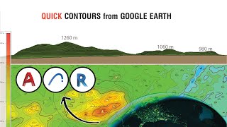
This minicourse consist in 3 video tutorials. In the first one, you are going to learn how to create a Digital Elevation Model (DEM) with QGIS using data from Google Earth. In the second one, you are going to learn how to use LASTool to process LiDAR data to create a DEM with QGIS. Also, you are going to see how to get the contour lines from both models. The third one is going to be a comparison between the two models and we will have a discussion about the accuracy of the ground elevation from Google Earth data.
▶ What you are going to learn in Part 1:
✔ How to import a shp file to Google Earth
✔ Create a kmz file with the elevation data from Google Earth
✔ Export the Kmz file
✔ Convert the kmz file to txt file
✔ Open the txt file with QGIS
✔ Change the Coordinate Reference System (CRS) from WGS 84 (geographic) to NAD 83 Z11 (projected)
✔ Create a DEM base on Triangulated Irregular Network (TIN) with QGIS Contour lines extraction
✔ 3D model
▶ Links of interest:
https://www.gpsvisualizer.com/elevation
https://docs.qgis.org/3.16/en/docs/ge...