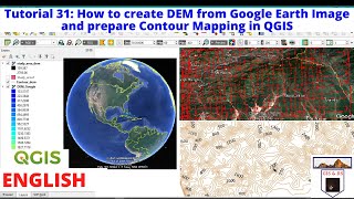
Create contours and DEM using Google Earth and QGIS 2.10

This video demonstrates, step by step, how to create contour lines and DEM ( Digital Elevation Model) using free tools: Google Earth, TCX Converter and QGIS 2.10.
You know that QGIS can generate DEM and contours from a points cloud which contains altitude information.
So, we used the Path tool in Google Earth to create the points cloud and we exported them to a KML file.
Then, we used TCX Converter to get altitude data of the points (internet connection needed) and export them to a CSV file.
Finally, we imported the CSV in QGIS 2.10 and we used SAGA tools to generate a DEM and contour lines.
You can download TCX Converter here: http://www.tcxconverter.com/TCX_Conve...
For more tutorials, visit our blog : http://mondegeospatial.com/createco...
Subscribe to our Channel : / @mondegeospatialcom