Create Digital Map using Google Earth Engine

Hi Geospatial Enthusiast!
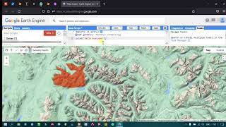
In this video, I will show you how to make a simple digital map using Google Earth Engine. The purpose is that you could do some analysis in GEE and then share the result with your friends and colleagues where it looks like an actual map. Using this, you don't have to create a webGIS from scratch and just use available features in GEE. Of course, the performance might be slower due to the analysis script that you use.
Script: https://code.earthengine.google.com/9...
Result: https://eeramiqcom.projects.eartheng...
In creating a topography map using multiple data such as elevation from SRTM, river from Global Surface Water, road from GRIP, and administrative center from GPW. The location is South Sumatra province, Indonesia. You could use any other data and other locations.
I hope this video helps.
Email: [email protected]
Linkedin: / ramiqcom
GitHub: https://github.com/ramiqcom