Creating a Digital Twin with 3D Geospatial Data ArcGIS Pro and Python
Digital twins are quickly becoming an important data management and representation tool for a wide variety of applications. In the geospatial world, digital twins continue to receive attention for the Unique aspects that geospatial content can bring to a digital twin representation such as urban planning.
If you want to learn more about digital twins and how to create one using 3D Geospatial Data, geographic information system software and python programming, this video is for you!
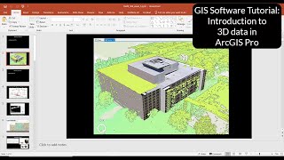
In this video I’ll teach you how to create a digital twin that is based on a threedimensional representation of a building using ArcGIS Pro software. The color of the building will change based on the temperature that is incorporated from real time data from the National Weather Service in the United States using a Python script.
Before getting into the tutorial, I’ll also first cover a few important background concepts about working with 3D data.
To achieve the tutorial end goal, I'll show you how you can build your specific 3D GIS skill sets each step of the way that include:
Create 3D objects from 2D objects
Shape the 3D object using Lidar data
Add textures to 3D objects
Connect the 3D object to a realtime weather feed using Python (ArcPy)
It was particularly exciting for me to develop this video and I found that there were so many ideas I was not able to include in this video but I'll provide you with some ideas that you might want to follow up based on your own creativity about the exciting world of digital twins.
It is also important to mention that no Python programming experience is required to follow the steps in this video as I provide you with a Python code file that you can load directly into the Arcgis Pro Python window. However, if you do have existing python coding skills, I will also provide a quick walkthrough of the code itself that you could use for a basis for building your own digital twins.
Video Chapters:
0:00:00 Beginning
0:00:45 What are Digital Twins?
0:01:59 Video Scope
0:02:33 Skills Taught Overview
0:03:52 Background Concept: Lidar
0:04:30 Background Concept: Multipatch Features
0:05:12 Background Concept: Vertical Coordinate Systems
0:05:44 Tutorial Introduction and Overview
0:06:10 Tutorial Hands On Start
0:06:13 Task 1 Step 1: Create a new ArcGIS Pro project
0:06:56 Task 1 Step 2: Add the tutorial datasets to your map
0:08:10 Task 2: Create a 3D Multipatch Object from 2D Polygons Overview
0:08:32 Task 2 Step 1: Create Scene View
0:09:31 Task 2 Step 2: Create Blank Multipatch Feature Class
0:10:33 Task 2 Step 3: Copy Footprints into Multipatch
0:11:22 Task 2 Step 4: Modify Multipatch using Lidar
0:12:27 Task 2 Step 5: Apply Textures
0:15:07 Task 3: Connect Python Script into Scene to Update 3D Multipatch Object in Real Time.
0:16:36 Task 4 Step 1: Export Scene Image
0:17:45 Python Code Walkthrough
0:22:39 Conclusion
Links and resources used in the video:
Datasets, Code, Instructions (free download): https://gisfordisastermanagement.com/...
Esri Digital Twins https://www.esri.com/enus/digitaltw...
Esri https://www.esri.com/enus/home
ArcGIS Pro: https://www.esri.com/enus/arcgis/pro...
21day ArcGIS Pro trial https://www.esri.com/enus/arcgis/pro...
ArcGIS for Personal Use https://www.esri.com/enus/arcgis/pro...
Lidar https://oceanservice.noaa.gov/facts/l...
Lidar data source: https://maps.monroecounty.gov/Html5Vi...
Multipatch https://pro.arcgis.com/en/proapp/lat...
Vertical Coordinate System https://pro.arcgis.com/en/proapp/lat...
NOAA weather feeds https://w1.weather.gov/xml/current_obs/
If you liked this and other videos on the geographic information science channel, please like these videos, leave comments, or subscribe to this channel so you can stay informed of new videos.
Subscribe to this channel:
https://www.youtube.com/user/GIScienc...
Also, feel free to contact me if you have any questions, I love hearing from the YouTube community.
Thanks for stopping by!
Brian Tomaszewski, Ph.D.
@bangeobrian
http://gisfordisastermanagement.com/
/ briantomaszewski452b1387