Easy way to get 15 free YouTube views, likes and subscribers

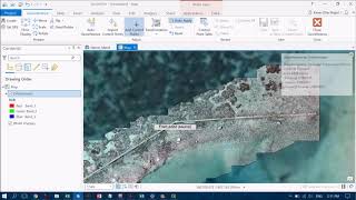
Creating Orthomosaics in ArcGIS Pro with Drone Imagery

Using the Ortho Mapping tool in ArcGIS pro is very easy and effective if you have some geotagged drone data! I show you how to use the basic features of the Ortho Mapping module with a subset of data over Heron Reef. The quality of the resultant mosaic is incredible! If you would like to try it out using some sample data, check out http://www.geonadir.com/ and you can download from there


Recommended