Data Science Made Easy in ArcGIS using Python and R

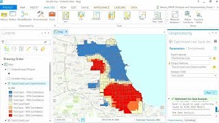
Python and R provide a wide array of powerful modules that can expand the data science capabilities of ArcGIS. This session outlines integration techniques that allow you to call open source statistical packages to quantify patterns and relationships in your data. The session further details methods that take the guesswork out of transferring data between ArcGIS and the Python and R environments, demonstrating how to easily incorporate advanced analytical techniques into your daily workflows. The material is freely available on GitHub in the form of ArcGIS Toolboxes and Jupyter Notebooks in order to demonstrate the vast capabilities available to you. This session promotes interaction with the audience, so come join the discussion and be prepared to learn about the many possibilities at your fingertips for exploring your spatial data.