Sign In
Home
Popular
News
Popular now
New music
Cute animals
Trending today
Hot trailers
Popular music
Comedy clips
New tech
Popular sports
Learn new
A little secret to rock your YouTube subscribers
Animals
Babies
Beautiful
Cats
Creative
Cute
Dogs
Educational
Funny
Heartwarming
Holidays
Incredible
Inspirational
Interesting
Love
Music
Nature
Oops
Performance
Pranks
Science
Sports
Technology
Unexpected
Cat Humor
Best Puppy Videos
Cover Song Charts
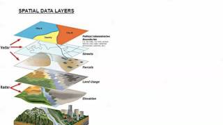
Data Structure in GIS – Raster and Vector Data
Back
Follow
Subject:Environmental Sciences
Paper: Remote sensing & GIS applications in environmental science
posted by
lollampog8f
[ f ] Share this video on Facebook
Raster data models and comparisons with vector
GIS data structure raster vs vector
A brief introduction to GIS Data: raster and vector
Raster data model in GIS (theory)
Different types of vector data and concept of topology
What is Remote Sensing and GIS?
Introduction to GIS. KnowGIS Professional Training 2 of 13
Lecture 06 : Raster data model and comparisons with vector
How I Would Learn GIS (If I Had To Start Over)
Fundamentals of Remote Sensing
Spatial database systems and their types
Geographic Information Systems (GIS) concepts simplified
Introduction to GIS
Basic of remote sensing
GIS overlays special analysis
Lecture 03 : Different types of vector data
Lecture 11: Spatial Database: An Overiew
Georeferencing an Image or a Scanned Map using ArcGIS Pro
How to Perform a Simple Spatial Data Analysis using QGIS
Different components of GIS
Recommended
This Proposal Will Make A Stone Cry
21:10
Battleship For Battle Atheists
15:32
Keep Calm & Jump Like A Boss!
00:17
Keep Your Cool & Pay More For Payless!
01:37
Benedict Cumberbatch & His Bad Present Reaction School
06:28
John Oliver Unmasks 50 Shades Of FIFA II
13:13
Best Christmas Card For Everyone!
02:18
Hight School Today & 10 Years Ago
05:40