DEM Generation using Sentinel-1 images in SNAP

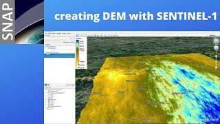
A Digital Elevation Model, also known as a DEM, is a type of raster layer. They are raster grids of the Earth’s surface referenced to the vertical datum—the surface of zero elevation to which heights are referred to by scientists, insurers, and geodesists. DEMs are critical in areas such as infrastructural management, hydrology and flowdirection studies, and landuse planning. DEM can be generated with different methods or can be downloaded from related websites. one of the suitable ways to generate DEM is satellite images, in this video we've used Sentinel images, which are appropriate for this purpose, to generate DEM. All of the processes have been performed in SNAP software because of its performance in processing sentinel images. in this video, you learn how to generate the DEM from A to Z using sentinel images. if you have any questions, you can leave us a comment.
Copernicus website to download images:
✅ https://scihub.copernicus.eu/dhus/#/home
_ _ _ _ _ _ _ _ _ _ _ _ _ _ _ _ _ _ _ _ _ _
The website to download the SNAP:
✅ http://step.esa.int/main/download/sna...
_ _ _ _ _ _ _ _ _ _ _ _ _ _ _ _ _ _ _ _ _ _
The website to find and download SAR, InSAR, and other data
✅https://search.asf.alaska.edu/
_________________________________
_________________________________
Subscribe to our channel and Like the video:
✅ / channel
_ _ _ _ _ _ _ _ _ _ _ _ _ _ _ _ _ _ _ _ _ _
Share the video with others:
✅ • DEM Generation using Sentinel1 image...
_________________________________
Timeline:
00:00 Introduction
00:28 Download the perfect Sentinel1 image to generate a DEM
02:27 Choose the appropriate Sentinel1 image on the Alaska site
07:46 Download and install Snap software plugins
09:55 Install SNAPHu Unwrapping in SNAP
11:50 DEM Generation in SNAP
11:56 S1 TOPS Split
13:41 Apply Orbit File
14:31 Coregistration S1 Back Geocoding
15:31 S1 Enhanced Spectral Diversity
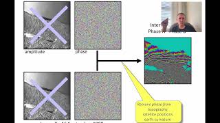
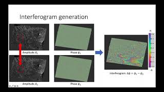
16:13 Interferogram Formation
17:35 S1 TOPS Deburst
18:35 Interferometric Goldstein Phase Filtering
20:00 Snaphu Unwrapping
25:22 Interferometric Phase to Elevation DEM Generation
28:40 Geometric Terrain Correction Range Doppler Terrain Correction
30:04 How to export KMZ format from DEM
31:06 DEM illustration in Google Earth
_________________________________
DEM Generation using Sentinel1 images in SNAP
#DEM #DEM_Generation #SNAP #DEM_Generation_using_Sentinel_1_images_in_SNAP #DEM_Generation_using_Sentinel_1 #DEM_Generation_in_SNAP #SNAP #Sentinel #Sentinel_1 #Sentinel_1_images #sar #remote_sensing #GIS #RADAR #microwave #microwave_remote_sensing #active_remote_sensing #sar_analysis #sentinel_1 #copernicus #gis_tutorial #gis_and_remote_sensing #geospatial #esa_snap #snap_desktop #mapping #geographic_information_system #remote_sensing_tutorial #digital_image_analysis #data #synthetic_aperture_radar #esa_snap_tutorial #synthetic_aperture_radar_tutorial #snap_tutorial #sentinel_tutorial #sentinel_1_tutorial #tutorial #copernicus_hub
#DEM_illustration_in_Google_Earth #Export_KMZ_format_DEM #Geometric #Terrain_Correction #Range_Doppler_Terrain_Correction #Interferometric #eaxtract_dem #Snaphu_Unwrapping #Snaphu #TOPS_Deburst #Interferogram_Formation #Enhanced_Spectral_Diversity #Spectral_Diversity #Coregistration #Coregistration_sentinel #Coregistration_in_snap #Apply_Orbit_File #TOPS_Split #Install_SNAPHu_Unwrapping_in_SNAP #Install_SNAPHu #Install_SNAPHu_Unwrapping #esa_snap_dem_extraction #digital_elevation_model #dem #dsm #dtm #extract_dem #creating_dem #creating_dem_with_sentinel_1 #creating_dem_with_sentinel
#creating_dem_in_snap #SNAP #Dem_extract #DEM_Extraction #DEM_Extraction_using_SNAP #DEM_Extraction_using_Sentinel_1 #DEM_Extraction_using_sar_image RS & GIS #RSandGIS