Denver - Vancouver flight UA323: 1st-Class lunch over Rockies Grand Teton Mt. Baker 2017-01-28
A firstclass burger lunch flight from the United Airlines Rockies hub over the snowy Front Range, Teton Mountain, Bitterroot Range and volcanic Mount Baker of the North Cascades at Bellingham enroute to Canada's West Coast gateway Vancouver.
0:01 Flight details from cockpit
0:35 On screen flight highlights
3:33 Takeoff run begins on runway 34L
Runway 16R/34L, with a length of 16,000 feet (4,877 m), is the longest public use runway in the United States
5:005:32 Barr Lake State Park & Interstate 76
5:52 10,000' chime
5:546:08 Brighton, Adams and Weld counties, Colorado
6:10 Crossing front Range of Rockies west of Boulder CO
8:57 Seatbelt sign off north of Craig CO
9:55 Interstate 80, Wyoming near Continental Divide
10:45 Jim Bridger Power Plant, 9 Miles E, Point of Rocks, Wyoming
12:05 Inflight drink & mixed nuts
12:15 Inflight lunch: cheeseburger & salad
12:25 Teton Mountains, Grand Teton, Jackson Hole & Snake River, Wyoming
Jackson Hole is a valley between the Teton Mountain Range and the Gros Ventre Range in Wyoming. The term "hole" was used by early trappers or mountain men, who primarily entered the valley from the north and east and had to descend along relatively steep slopes, giving the sensation of entering a hole. These lowlying valleys surrounded by mountains and containing rivers and streams are good habitat for beaver and other furbearing animals.
https://en.wikipedia.org/wiki/Jackson...
13:00 Entering Idaho
17:2518:00 Centennial Mountains & Snowcrest Range, Idaho
18:00 Garfield Mountain & Scott Peak, Idaho
19:00 Canadian arrival declaration form announcement
21:55 Peaks near Salmon, Idaho
22:40 SelwayBitterroot Wilderness, Idaho
24:25 Middle Fork Clearwater River, Idaho County, Idaho
https://en.wikipedia.org/wiki/Middle_...
25:37 Bruce Eddy, Dworshak Reservoir, Idaho
28:08 North Cascades, Cascade Range, Whatcom County, Washington, Cascade Volcanic Arc
27:36 Destination weather condition reported from cockpit
28:2132:00 Mount Baker 10,781 ft / 3,286 m, Whatcom County, WA
31:0032:10 Sisters Mountain 7,013' / 2,140 m
32:25 Fraser Valley; Deming, Nooksack River Valley WA
33:10 Lake Whatcom
34:40 Bellingham WA 2010 population: city 80,885; metro: 212,284
34:50 University of Western Washington (WWU / Western)
35:50 Ferndale WA
36:15 Lake Terrell WA
37:05 Drayton Harbor & Birch Bay WA
37:20 Semiahmoo Bay BC & WA
38:10 Blaine WA
38:20 International boundary
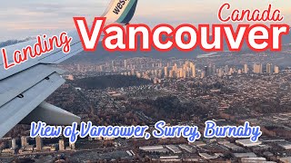
38:35 South Surrey BC
38:45 White Rock Pier, White Rock BC
39:25 Crescent Beach BC
39:32 Boundary Bay BC
39:50 Fraser River BC
40:15 Vancouver/Boundary Bay Airport (IATA: YDT, ICAO: CZBB)
Delta BC
40:25 Highway 99, Delta BC
41:05 Ladner, Delta BC
41:10 Deas Island Highway 99 Fraser River crossing tunnel
41:20 Fraser River, Kirkland island, Williamson Slough, Duck Island, Gunn Island, Barber Island, Ladner Harbour Park
41:25 Highway 99 (to Vancouver); North Arm of Fraser River, Vancouver International Airport, (Sea Island); Richmond BC
41:45 West Vancouver, English Bay, North Vancouver
42:05 Hollyburn Mountain 4,350' / 1,325 m., West Vancouver BC
42:40 Howe Sound (to Whistler BC)
42:40 University of British Columbia (UBC) Point Grey, Vancouver BC
42:40 Wreck Beach, Pacific Spirit Regional Park, Vancouver BC
42:40 Iona Jetty, Greater Vancouver treated sewage outflow hikebike path, Richmond BC
42:50 Bowen Island BC
49:45 Runway 13
50:00 Touching down on runway 8L (9,940' / 3,030 m)
More aircraft & flight routing information:
http://flightaware.com/live/flight/UA...