Digital Elevation Model DEM Expalined

Digital Elevation Model (DEM)
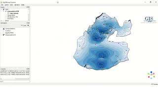
A Digital Elevation Model, or DEM for short, is like a virtual map that shows the height or elevation of the Earth's surface. Just like a regular map shows us the roads, rivers, and cities, a DEM shows us how high or low different areas of the land are. Imagine you're looking at a picture of a mountain. The DEM is like a grid placed over that picture. Each square in the grid represents a tiny part of the mountain. Inside each square, there's a number that tells us how high that part of the mountain is above sea level.
To create a DEM, scientists use special tools and technology to measure the elevation of the land. They may use things like airplanes equipped with lasers or satellites that can see the Earth from space. These tools send out signals or beams of light that bounce off the land and come back to the sensors. By measuring the time it takes for the signals to return, scientists can calculate the height of the land. DEM data is really useful because it helps us understand the shape of the land. We can see where there are mountains, valleys, and even things like cliffs and slopes. This information is important for many different things. For example, it helps us plan where to build roads and buildings, predict where floods might happen, and study the natural environment.
When you work with a DEM, you can create 3D models or visualizations that make it easier to understand and explore the land. It's like looking at the Earth from above and being able to see the height of different places. In summary, a DEM is a digital map that shows us the height or elevation of the land. It's made by measuring the land's height using special tools, and it helps us understand and study the Earth's surface in various ways.
Talking about the DEM data, it is used in various fields and applications for example.
Geography and Geology: DEMs are widely used in geography and geology to study the Earth's surface. They help in understanding landforms, such as mountains, valleys, and plateaus, and analyzing their characteristics, such as slopes, aspect, and drainage patterns.
• Hydrology: DEMs play a crucial role in hydrological studies. They are used to model and analyze water flow, watershed boundaries, and drainage networks. DEMs help in predicting flood patterns, locating suitable sites for reservoirs, and managing water resources effectively.
• Environmental Science: DEMs are used in environmental studies to assess the impact of natural disasters, such as landslides and erosion. They aid in evaluating soil erosion, sediment transport, and habitat suitability for different species. DEMs also help in analyzing the effects of climate change on landscapes.
• Urban Planning and Infrastructure Development: DEMs are utilized in urban planning to determine suitable locations for infrastructure projects like roads, buildings, and utilities. They assist in site selection, analyzing the impact of proposed developments on the landscape, and designing efficient drainage systems.
• Engineering and Construction: DEMs are valuable in engineering applications. They provide accurate elevation information for designing transportation routes, calculating earthwork volumes, and assessing slope stability. DEMs also aid in infrastructure maintenance and monitoring, such as detecting changes in the elevation of dams and bridges.
• Natural Resource Management: DEMs are used in managing natural resources like forests, minerals, and water. They help in assessing terrain characteristics, estimating timber volume, identifying potential mining sites, and planning the extraction of natural resources.
• Cartography and Visualization: DEMs serve as a foundation for creating topographic maps and visualizations. They enable the generation of threedimensional representations of the land, which are useful in cartography, virtual reality applications, and GIS software for spatial analysis.
These are just a few examples of the broad range of applications for DEM data. The versatility of DEMs makes them valuable across multiple disciplines, providing valuable insights into the Earth's surface and supporting decisionmaking processes in various fields.