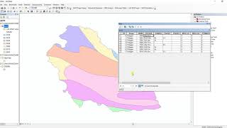
Digital Soil Map || Soil Properties and Crop Map of Nepal || NARC Soil Map ||

Digital Soil Map (DSM) is a computerassisted production of digital maps of soil properties. This is developed by using mathematical and statistical models that combine soil information from laboratory analysis with environmental variables (soil forming factors).
Soil Data collected from detailed soil survey from pits at 10000 scales. Soil morphological characteristics and properties such as texture, structure, consistency, mottles, porosity, compactness, pH, color, slope and drainage analyzed in each pit. Texture (sand, silt, clay %), pH, Total N, Available P, Available K, Boron, Zinc and Organic matter analyzed from physical and chemical analyses of soil samples at soil lab.
How can I get soil information of my farm land?
You may use a point or polygon tool on the soil map. You can either click on the farm land or draw a polygon over your farm. The output (soil properties) will be generated in a tabular form that can be downloaded. Caution: The values generated are based on the prediction results, so please consult experts for their interpretation and taking decisions about future farm operation or perform detailed soil analysis for taking further decisions.
Link to the site: https://soil.narc.gov.np/soil/soilmap/
#soilmap #narcSoilmap #ph #soilproperties
Link to other Videos:
An Absolute Guide for Beginners || Beginners Series For ArcGIS || Part 2 || @GeoTech Studio
• An Absolute Guide for Beginners || B...
Absolute Guide For ArcGIS Beginners || Beginner Series For ArcGIS || Part 1:
• Video
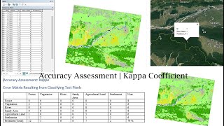
Accuracy Assessment || Kappa Coefficient || Overall Accuracy:
• Video
Equal Block Division based on Area:
• Video
DEM and LULC Data Preparation for SWAT Model :
• DEM and LULC Data Preparation for SWA...
Soil Map Preparation for SWAT Model :
• Soil Map Preparation for SWAT Model |...
Data Preparation SWAT Model : Soil Properties Data || SWAT Simulation:
• Data Preparation SWAT Model : Soil Pr...
Installation of ERDAS Imagine 2015:
• Video
Mosaicing in GIS:
• Mosaicing in GIS || Extraction of AOI...
Slope Analysis from DEM in ArcGIS:
• Slope Analysis from DEM in ArcGIS || ...
Digitization in QGIS Using Snapping Options
• Digitization in QGIS Using Snapping O...
Georeferencing on QGIS
• Georeferencing on QGIS || @GeoTech_St...
Hotspot Analysis Using ArcMap:
• Hotspot analysis using ArcGIS || Crim...
Stream Order Analysis from a Digital Elevation Model using ArcGIS 10.X
• Stream Order Analysis from a Digital ...
Extraction or Digitization of Land features using Landsat 8 Data:
• Extraction or Digitization of Land fe...
Calculating Land Surface Temperature using Landsat 8 images by ArcGIS:
• Extraction or Digitization of Land fe...
Calculating the Criteria Weight by Multiple Criteria Decision Making :
• Calculating the Criteria Weight by Mu...
Interpolation:
• Heat Distribution Mapping Using diffe...
Thematic Mapping of COVID19:
• Thematic Mapping of COVID 19 || Gener...
Study Area Mapping:
• Study Area Mapping Using ARCGIS ||10....
Landuse Land Cover link:
• Land Use Land Cover Mapping | Image C...
Landslide Assessment video link:
• How to do Landslide Analysis in Arcgi...
USGS data downloading tutorial video link:
• Download Dem or landsat data from Goo...
Fire Risk Assessment video link:
• Fire Risk Zonation or Assessment On A...
Water Delineation Tutorial link:
• How to use a DEM to delineate a Water...
Georeferencing On ArcMap:
• Georeferencing In ArcGIS (Bhuwan Paud...
Official Gmail ID: [email protected]