DJI L1 and Matrice 300 RTK first DJI LiDAR Laser Hybrid System

L1 Eine Lidar & RGBLösung für Vermessung aus der Luft
Unser erster Test der neuen L1 LiDAR & Photogrammetrie Hybridlösung für Vermessungsanwendungen mit der DJI M300 RTK exklusiv für die InterGEO2020!
Erfahren Sie mehr unter: https://www.globeflight.de/DJIL1'>https://www.globeflight.de/DJIL1'>https://www.globeflight.de/DJIL1'>https://www.globeflight.de/DJIL1
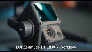
Die Zenmuse L1 integriert ein Livox LidarModul, eine hochpräzise IMU und eine Kamera mit einem 1ZollCMOS Sensor in ein 3Achs Gimbal.
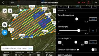
In Verbindung mit der Matrice 300 RTK und DJI Terra bildet der L1 eine Komplettlösung, die Ihnen in Echtzeit 3DDaten generiert, welche die Details komplexer Strukturen effizient erfassen und hochpräzise rekonstruierte Modelle liefern.
TECHNISCHE DATEN: vertikale Genauigkeit: 5cm / horizontale Genauigkeit: 10cm (50m Höhe), 2 km² Abdeckung in einem einzelnen Flug mit über 200 Punkten/m², Punktrate: 240.000 Punkte/s, Unterstützt 3 Returns, Erfassungsbereich: 450m (80% Reflexionsgrad, 0 klx), IP44, Point Cloud LiveView
L1 A Lidar & RGB Solution for Aerial Surveying
Our first test for InterGEO2020 with the M300 RTK and L1 LiDAR Laser and camera hybrid system!
Request more information here: https://www.globeflight.de/DJIL1'>https://www.globeflight.de/DJIL1'>https://www.globeflight.de/DJIL1'>https://www.globeflight.de/DJIL1
The Zenmuse L1 integrates a Livox Lidar module, a highaccuracy IMU, and a camera with a 1inch CMOS on a 3axis stabilized gimbal.
When used with Matrice 300 RTK and DJI Terra, the L1 forms a complete solution that gives you realtime
3D data throughout the day, efficiently capturing the details of complex structures and delivering highly accurate
reconstructed models.
TECH SPECS: Vertical Accuracy: 5 cm / Horizontal Accuracy: 10 cm (50m height), 2 km² Coverage in a single flight with more than 200 points/m², Point Rate: 240,000pts/s, Supports 3 Returns, Detection Range: 450m (80% reflectivity, 0 klx), IP44, Point Cloud LiveView
https://www.globeflight.de/