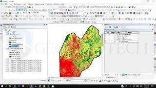
Download 10 m Resolution Land Use Map || Sentinel-2 Land Use Land Cover Map Download ||

In this video will teach you the process of downloading readily available Land Use Land Cover Map freely. For Large Scale spatial analysis it can be very effective. Hydrologic modelling, food security, and conservation planning are just a few of the topics covered by global land use/cover maps. Everywhere on Earth, land usage and land cover may be visualised using this information.
..............FOR ANY QUERY PLEASE FEEL FREE TO COMMENT..........
For more tutorial click on the links below:
• Land use/land cover classification in ArcGIS: • Supervised Classification of LANDSAT ...
• Supervised image classification: / watchv=ilt7vs7rshk&t=943s
• Unsupervised Image Classification: • Unsupervised Classification in GIS ||...
• Direct Download of Slope Map, Roughness Map, Slope Aspect Map of Any Area: • Direct Download of Slope Map, Roughne...
• How to download satellite imagery: • How to Download Satellite Imagery || ...
• Digitization in ArcGIS: • How to digitize in ArcGIS || Digitiza...
• Slope and Aspect Map: • Slope and Slope Aspect Map in GIS || ...
• Converting Shapefile/Layer to KML/KMZ file || How to convert Shapefile/Layer into KML file in ArcMap: • Converting Shapefile/Layer to KML/KMZ...
• Map Layout in ArcGIS || How to Make Map Layout in GIS || Create Map Layout in GIS: • Create Map Layout in GIS|How to Creat...
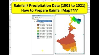
• Annual Average Rainfall Map in ArcGIS ||How to Download Precipitation Data: • Rainfall Map in ArcGIS || Annual Aver...
• How to Download GIS Shapefiles: • How to Download GIS Shapefiles || Sha...
• Direct Download of Slope Map, Roughness Map, Slope Aspect Map of Any Area: • Direct Download of Slope Map, Roughne...
• Projection & Coordinate system transformation of Raster || How to Change Coordinate System in ArcGIS: • Projection & Coordinate system transf...
• How to Create Study Area Map in ArcGIS | Creating Location Map of Study Area: • How to Create Study Area Map in ArcGI...
• NDBI in ArcGIS : • NDBI in ArcGIS || Normalize Differenc...
• How to download LISS 4 & LISS 3 satellite imagery: • LISS 4 &LISS 3 data download freely |...