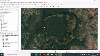
Download and georeference Google Earth images in QGIS 2.8 with OpenLayers Plugin

In this tutorial you will discover a method to download and georeference Google Earth image in QGIS 2.8 with OpenLayers Plugin.
the steps to do this are :
1 Localize and download the image from Google earth Pro.
2 Install the OpenLayers plugin in QGIS (if it is not installed)
3 Add the Google Satellite layer of the OpenLayers plugin to the QGIS map.
4 Open downloaded image in the QGIS Georeferencer.
5 Add control points the the image using similar points in the Google Satellite layer....
Georeferenced images can be used in QGIS or other software like ArcGIS
For more GIS / Geospatial tutorials, visit : http://mondegeospatial.com
Subscribe to our Channel : / @mondegeospatialcom
Like our page on Facebook : / mondegeospatial
Follow us on Twitter : / mondegeospatial
Follow us on Google+ : http://plus.google.com/+Mondegeospati...
Follow us on Pinterest : / geospatialgis


![Cómo usar GOOGLE FORMS [ formularios paso a paso ]](https://i.ytimg.com/vi/PrnH8qLuf1Y/mqdefault.jpg)