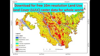
Download Free ESRI 10m Land Use/Land Cover Maps with LULC ESRI: A Comprehensive Tutorial

To briefly explain, Land cover data documents how much of a region is covered by forests, wetlands, impervious surfaces, agriculture, and other land and water types. Water types include wetlands or open water. Land use shows how people use the landscape – whether for development, conservation, or mixed uses.
since 2017 Esri has provided LULC 10m using Sentinel2 images which can be downloaded easily, in this video we've attempted to show you how to download 10m LULC maps as easy as possible.
__________
in this video we've shown you how to download ESRI 10 meter Land Cover Maps step by step & For Free.
__________
Check it out:
Like & Share the video with others:
✅ • Download Free ESRI 10m Land Use/Land ...
_ _ _ _ _ _ _ _ _ _ _ _ _ _ _ _ _ _ _ _ _ _
Subscribe to our channel :
✅ / @rsgis6997
=========================================================
#gis #gistutorial #remotesensing #rsandgis #arcgis