Download Geology Shapefile for any Location | USGS

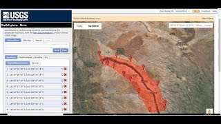
In this tutorial, you will learn how to download and visualize geology shapefiles for any location. The United States Geological Survey (USGS) is a scientific agency of the United States government that is responsible for studying the country's geology, natural resources, and the environment. One of the USGS's most important contributions to geology is the creation of World Geologic Maps.
Link for World Geologic Maps: https://certmapper.cr.usgs.gov/data/a...
Link for Download World County Boundary:
https://public.opendatasoft.com/explo...
World Geologic Maps are detailed, largescale maps that depict the geology of a particular region or country. They are typically created by combining field observations, geologic maps, and other types of geologic data into a comprehensive and detailed representation of the area's geology. World Geologic Maps are invaluable tools for geologists, engineers, and other scientists who are interested in understanding the structure and composition of the Earth's crust.
The USGS has been creating World Geologic Maps for over a century. In the early 20th century, the USGS began creating geologic maps of the United States, which provided detailed information about the country's geology, mineral resources, and other natural features. Over time, the USGS expanded its mapping efforts to include other parts of the world, creating World Geologic Maps for countries such as Mexico, Australia, and Canada.
Today, the USGS continues to produce World Geologic Maps using a variety of methods, including satellite imagery, aerial photography, and other advanced mapping technologies. These maps are made available to the public online, allowing anyone to access detailed information about the geology of a particular region.
The USGS's World Geologic Maps are essential tools for scientists, engineers, and policymakers who are interested in understanding the Earth's geology and natural resources. By providing detailed information about the composition and structure of the Earth's crust, these maps help researchers to better understand geological processes, identify potential hazards, and locate valuable resources.
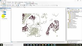
By the end of this tutorial, you will have a good understanding of how to work with geology shapefiles and use GIS software to analyze and visualize geological data. This tutorial is suitable for beginners who are interested in geology, mapping, and data visualization, as well as professionals who work with geospatial data.
Join this channel to get access to perks:
/ @terraspatial
#geologicalmap #usgs #download #geology #shapefile #worldgeologicalmap