A little secret to rock your YouTube subscribers

Download Install and Perform Watershed Delineation with ArcHydro Tool

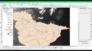
Hello everyone, I hope you are doing fine. Today, we will learn watershed delineation based on Digital Elevation Model data (DEM). We will use Arc Hydro tool in ArcGIS workflow for this. First, we will show you how to download the ArcHydro tool for free of cost and then how to install this tool and add it to ArcMap. After that, we will show you how to delineate watersheds using this tool in ArcGIS.


Recommended