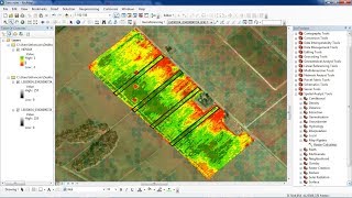
Download NDVI image using GEE u0026 Visualize using ArcGIS

In this video tutorial, I will demonstrate how to perform NDVI (Normalized Difference Vegetation Index) and download it using Google Earth Engine (GEE). We will then visualize the downloaded NDVI image in ArcGIS.
Sharable Code for Practice: https://code.earthengine.google.com/b...
Join this channel to get access to perks:
/ @terraspatial
00:00 Introduction
01:41 Importing Landsat 8 image
01:58 Cloud Filtering
02:07 Choosing Study Area
03:15 NDVI Analysis
04:42 Setting Visualizing Parameter / Color
05:58 Exporting NDVI image
06:47 Running Code
06:58 Visualizing Result Image
08:45 Downloading NDVI image / Earth Engine
10:27 Visualizing NDVI image in ArcGIS
**************************************
More Information on TOPIC NDVI:
**************************************
NDVI stands for Normalized Difference Vegetation Index. It's a numerical indicator used in remote sensing and satellite imagery analysis to assess and monitor the health and abundance of vegetation in a particular area. NDVI is calculated using the reflectance values of visible and nearinfrared light captured by remote sensors.
Here's how NDVI is calculated:
NDVI = NIRRed / NIR+Red
Where:
• NIR (NearInfrared) is the reflectance value in the nearinfrared spectrum (typically around 800900 nm).
• Red is the reflectance value in the red spectrum (around 600700 nm).
NDVI values typically range from 1 to +1, with meaningful values falling between 0.1 and 0.9. The interpretation of NDVI values is as follows:
• High Negative Values (1 to 0.1): These areas usually represent water bodies or surfaces with little to no vegetation.
• Low Values (0.1 to 0.2): These areas might include bare soil, rocks, or sparse vegetation.
• Moderate Values (0.2 to 0.5): These values indicate moderate levels of vegetation cover, such as grasslands and shrublands.
• High Values (0.5 to 0.9): These areas typically represent dense and healthy vegetation, such as forests or croplands.
NDVI is widely used for various applications, including:
1. Assessing Vegetation Health: NDVI can help monitor changes in vegetation health over time, including stress caused by factors like drought, disease, or pollution.
2. Land Use Planning: NDVI can be used to map land cover types, helping urban planners and land managers make informed decisions about land use and development.
3. Agriculture: Farmers and agronomists use NDVI to monitor crop health, identify stress or nutrient deficiencies, and make decisions about irrigation and fertilization.
4. Ecology and Conservation: NDVI is used to study ecosystems, track deforestation, and monitor habitat changes for various species.
5. Climate Change Studies: NDVI data can be used to analyze the impact of climate change on vegetation patterns and biodiversity.
6. Disaster Management: NDVI can aid in assessing the extent of damage caused by natural disasters like wildfires, hurricanes, and earthquakes.
Overall, NDVI is a valuable tool in the field of remote sensing, providing critical information about the state of vegetation and the environment.
#googleearthengine #ndvi #download #visualize #ArcGIS #geospatial #earthengine